You are here: Home > Network List > TA - USArray Transportable Network (new EarthScope stations) Stations List
> Station W40A Ferguson Farm, Pottsville, AR, USA > Earthquake Result Viewer
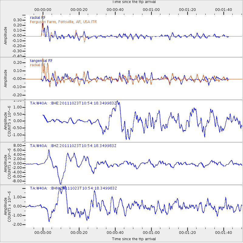
W40A Ferguson Farm, Pottsville, AR, USA - Earthquake Result Viewer
| Earthquake location: |
Turkey |
| Earthquake latitude/longitude: |
38.7/43.5 |
| Earthquake time(UTC): |
2011/10/23 (296) 10:41:22 GMT |
| Earthquake Depth: |
16 km |
| Earthquake Magnitude: |
6.9 MB, 7.3 MS, 7.3 MW, 7.1 MW |
| Earthquake Catalog/Contributor: |
WHDF/NEIC |
|
| Network: |
TA USArray Transportable Network (new EarthScope stations) |
| Station: |
W40A Ferguson Farm, Pottsville, AR, USA |
| Lat/Lon: |
35.19 N/93.07 W |
| Elevation: |
108 m |
|
| Distance: |
96.2 deg |
| Az: |
325.511 deg |
| Baz: |
32.738 deg |
| Ray Param: |
0.040577427 |
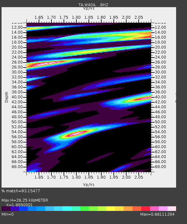
| Estimated Moho Depth: |
26.25 km |
| Estimated Crust Vp/Vs: |
1.69 |
| Assumed Crust Vp: |
6.498 km/s |
| Estimated Crust Vs: |
3.856 km/s |
| Estimated Crust Poisson's Ratio: |
0.23 |
|
| Radial Match: |
93.15477 % |
| Radial Bump: |
400 |
| Transverse Match: |
78.314 % |
| Transverse Bump: |
400 |
| SOD ConfigId: |
424168 |
| Insert Time: |
2012-02-16 06:00:01.022 +0000 |
| GWidth: |
2.5 |
| Max Bumps: |
400 |
| Tol: |
0.001 |
|
Signal To Noise
| Channel | StoN | STA | LTA |
| TA:W40A: :BHZ:20111023T10:54:18.349983Z | 31.411932 | 2.7412639E-6 | 8.726823E-8 |
| TA:W40A: :BHN:20111023T10:54:18.349983Z | 4.421455 | 6.913048E-7 | 1.5635234E-7 |
| TA:W40A: :BHE:20111023T10:54:18.349983Z | 4.0785294 | 4.9873415E-7 | 1.2228284E-7 |
| Arrivals |
| Ps | 2.8 SECOND |
| PpPs | 11 SECOND |
| PsPs/PpSs | 13 SECOND |


