You are here: Home > Network List > TA - USArray Transportable Network (new EarthScope stations) Stations List
> Station U39A Green Forest, AR, USA > Earthquake Result Viewer
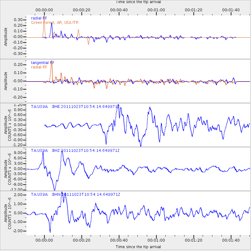
U39A Green Forest, AR, USA - Earthquake Result Viewer
*The percent match for this event was below the threshold and hence no stack was calculated.
| Earthquake location: |
Turkey |
| Earthquake latitude/longitude: |
38.7/43.5 |
| Earthquake time(UTC): |
2011/10/23 (296) 10:41:22 GMT |
| Earthquake Depth: |
16 km |
| Earthquake Magnitude: |
6.9 MB, 7.3 MS, 7.3 MW, 7.1 MW |
| Earthquake Catalog/Contributor: |
WHDF/NEIC |
|
| Network: |
TA USArray Transportable Network (new EarthScope stations) |
| Station: |
U39A Green Forest, AR, USA |
| Lat/Lon: |
36.38 N/93.48 W |
| Elevation: |
433 m |
|
| Distance: |
95.4 deg |
| Az: |
326.437 deg |
| Baz: |
32.405 deg |
| Ray Param: |
$rayparam |
*The percent match for this event was below the threshold and hence was not used in the summary stack. |
|
| Radial Match: |
95.09085 % |
| Radial Bump: |
398 |
| Transverse Match: |
86.747215 % |
| Transverse Bump: |
400 |
| SOD ConfigId: |
424168 |
| Insert Time: |
2012-02-16 06:07:34.090 +0000 |
| GWidth: |
2.5 |
| Max Bumps: |
400 |
| Tol: |
0.001 |
|
Signal To Noise
| Channel | StoN | STA | LTA |
| TA:U39A: :BHZ:20111023T10:54:14.649971Z | 46.511864 | 4.7762665E-6 | 1.02689214E-7 |
| TA:U39A: :BHN:20111023T10:54:14.649971Z | 10.072717 | 7.6703407E-7 | 7.614967E-8 |
| TA:U39A: :BHE:20111023T10:54:14.649971Z | 4.992628 | 4.2614175E-7 | 8.5354195E-8 |
| Arrivals |
| Ps | |
| PpPs | |
| PsPs/PpSs | |


