You are here: Home > Network List > TA - USArray Transportable Network (new EarthScope stations) Stations List
> Station 244A Avery, Jackson, MS, USA > Earthquake Result Viewer
244A Avery, Jackson, MS, USA - Earthquake Result Viewer

| Earthquake location: |
Turkey |
| Earthquake latitude/longitude: |
38.7/43.5 |
| Earthquake time(UTC): |
2011/10/23 (296) 10:41:22 GMT |
| Earthquake Depth: |
16 km |
| Earthquake Magnitude: |
6.9 MB, 7.3 MS, 7.3 MW, 7.1 MW |
| Earthquake Catalog/Contributor: |
WHDF/NEIC |
|
| Network: |
TA USArray Transportable Network (new EarthScope stations) |
| Station: |
244A Avery, Jackson, MS, USA |
| Lat/Lon: |
32.04 N/90.69 W |
| Elevation: |
59 m |
|
| Distance: |
97.7 deg |
| Az: |
322.091 deg |
| Baz: |
34.467 deg |
| Ray Param: |
0.040127564 |
| Estimated Moho Depth: |
12.0 km |
| Estimated Crust Vp/Vs: |
1.65 |
| Assumed Crust Vp: |
6.201 km/s |
| Estimated Crust Vs: |
3.753 km/s |
| Estimated Crust Poisson's Ratio: |
0.21 |
|
| Radial Match: |
89.12388 % |
| Radial Bump: |
400 |
| Transverse Match: |
84.63095 % |
| Transverse Bump: |
400 |
| SOD ConfigId: |
424168 |
| Insert Time: |
2012-02-16 06:09:20.690 +0000 |
| GWidth: |
2.5 |
| Max Bumps: |
400 |
| Tol: |
0.001 |
|
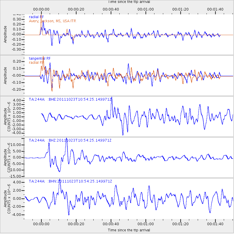
Signal To Noise
| Channel | StoN | STA | LTA |
| TA:244A: :BHZ:20111023T10:54:25.149971Z | 17.909609 | 4.2511188E-6 | 2.3736523E-7 |
| TA:244A: :BHN:20111023T10:54:25.149971Z | 2.3008142 | 1.0314224E-6 | 4.4828585E-7 |
| TA:244A: :BHE:20111023T10:54:25.149971Z | 1.1685599 | 5.1669684E-7 | 4.4216543E-7 |
| Arrivals |
| Ps | 1.3 SECOND |
| PpPs | 5.0 SECOND |
| PsPs/PpSs | 6.3 SECOND |


