You are here: Home > Network List > TA - USArray Transportable Network (new EarthScope stations) Stations List
> Station 245A Little AP, Star, MS, USA > Earthquake Result Viewer
245A Little AP, Star, MS, USA - Earthquake Result Viewer
| Earthquake location: |
Turkey |
| Earthquake latitude/longitude: |
38.7/43.5 |
| Earthquake time(UTC): |
2011/10/23 (296) 10:41:22 GMT |
| Earthquake Depth: |
16 km |
| Earthquake Magnitude: |
6.9 MB, 7.3 MS, 7.3 MW, 7.1 MW |
| Earthquake Catalog/Contributor: |
WHDF/NEIC |
|
| Network: |
TA USArray Transportable Network (new EarthScope stations) |
| Station: |
245A Little AP, Star, MS, USA |
| Lat/Lon: |
32.03 N/89.90 W |
| Elevation: |
104 m |
|
| Distance: |
97.3 deg |
| Az: |
321.529 deg |
| Baz: |
34.957 deg |
| Ray Param: |
0.040240284 |
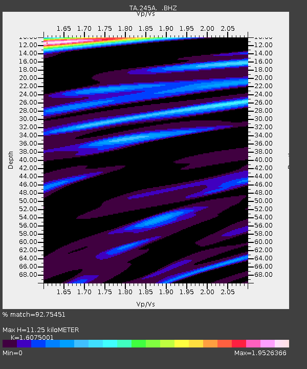
| Estimated Moho Depth: |
11.25 km |
| Estimated Crust Vp/Vs: |
1.61 |
| Assumed Crust Vp: |
6.201 km/s |
| Estimated Crust Vs: |
3.858 km/s |
| Estimated Crust Poisson's Ratio: |
0.18 |
|
| Radial Match: |
92.75451 % |
| Radial Bump: |
400 |
| Transverse Match: |
84.56152 % |
| Transverse Bump: |
400 |
| SOD ConfigId: |
424168 |
| Insert Time: |
2012-02-16 06:09:22.080 +0000 |
| GWidth: |
2.5 |
| Max Bumps: |
400 |
| Tol: |
0.001 |
|
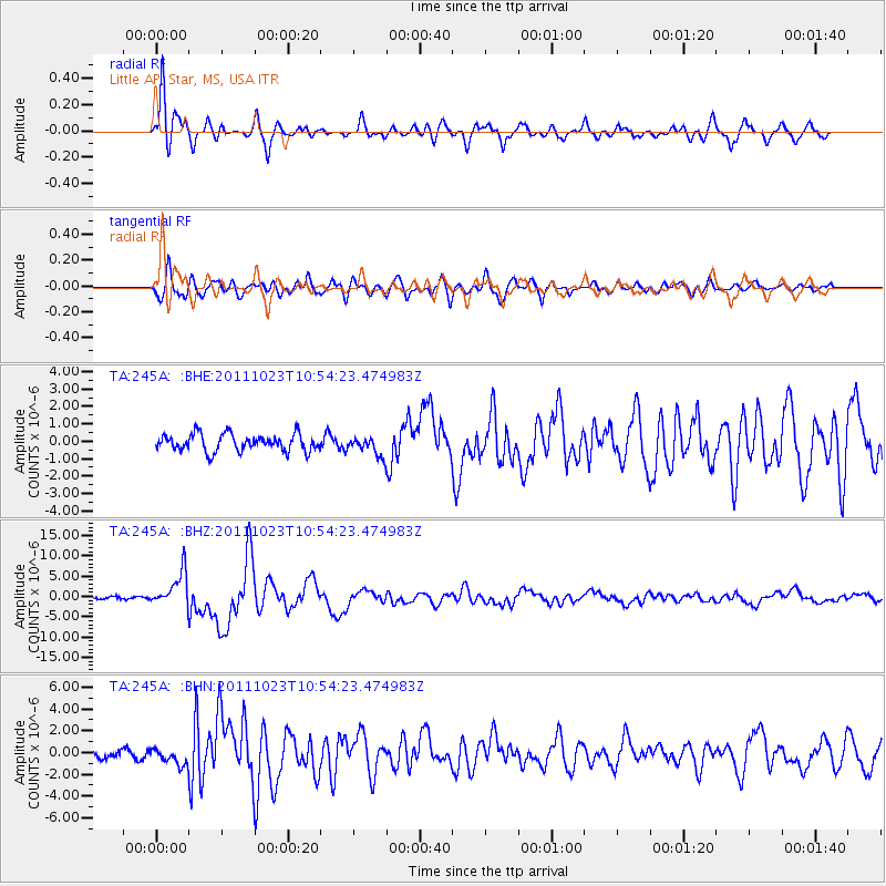
Signal To Noise
| Channel | StoN | STA | LTA |
| TA:245A: :BHZ:20111023T10:54:23.474983Z | 18.738443 | 4.2493816E-6 | 2.2677345E-7 |
| TA:245A: :BHN:20111023T10:54:23.474983Z | 1.7439244 | 7.311058E-7 | 4.1923022E-7 |
| TA:245A: :BHE:20111023T10:54:23.474983Z | 1.0930114 | 5.34324E-7 | 4.8885494E-7 |
| Arrivals |
| Ps | 1.1 SECOND |
| PpPs | 4.6 SECOND |
| PsPs/PpSs | 5.8 SECOND |


