You are here: Home > Network List > TA - USArray Transportable Network (new EarthScope stations) Stations List
> Station 144A alexander Place, Bentonia, MS, USA > Earthquake Result Viewer
144A alexander Place, Bentonia, MS, USA - Earthquake Result Viewer
| Earthquake location: |
Turkey |
| Earthquake latitude/longitude: |
38.7/43.5 |
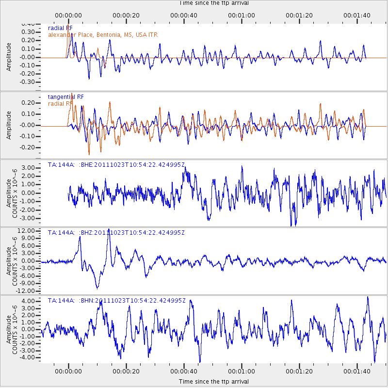
| Earthquake time(UTC): |
2011/10/23 (296) 10:41:22 GMT |
| Earthquake Depth: |
16 km |
| Earthquake Magnitude: |
6.9 MB, 7.3 MS, 7.3 MW, 7.1 MW |
| Earthquake Catalog/Contributor: |
WHDF/NEIC |
|
| Network: |
TA USArray Transportable Network (new EarthScope stations) |
| Station: |
144A alexander Place, Bentonia, MS, USA |
| Lat/Lon: |
32.63 N/90.42 W |
| Elevation: |
78 m |
|
| Distance: |
97.1 deg |
| Az: |
322.241 deg |
| Baz: |
34.587 deg |
| Ray Param: |
0.040311337 |
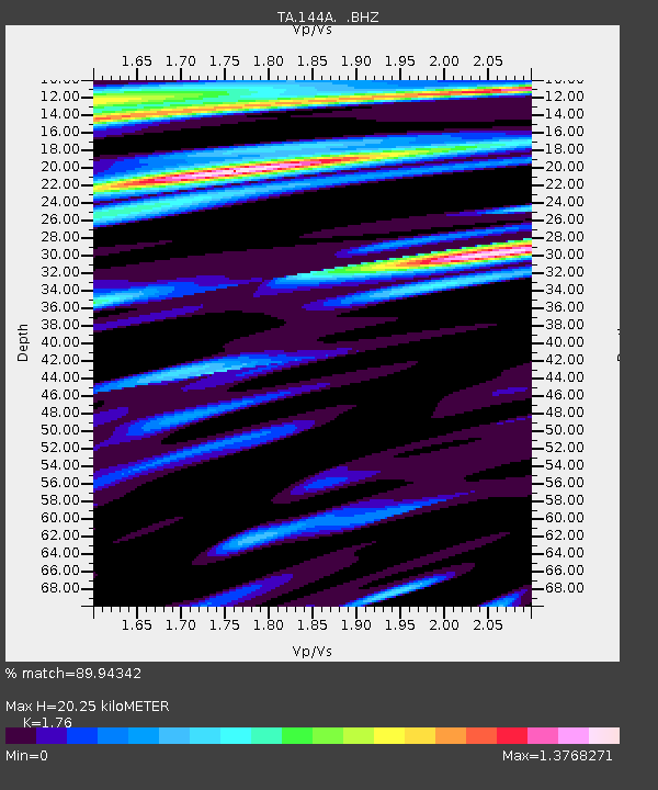
| Estimated Moho Depth: |
20.25 km |
| Estimated Crust Vp/Vs: |
1.76 |
| Assumed Crust Vp: |
6.201 km/s |
| Estimated Crust Vs: |
3.524 km/s |
| Estimated Crust Poisson's Ratio: |
0.26 |
|
| Radial Match: |
89.94342 % |
| Radial Bump: |
400 |
| Transverse Match: |
79.781044 % |
| Transverse Bump: |
400 |
| SOD ConfigId: |
424168 |
| Insert Time: |
2012-02-16 06:09:37.411 +0000 |
| GWidth: |
2.5 |
| Max Bumps: |
400 |
| Tol: |
0.001 |
|
Signal To Noise
| Channel | StoN | STA | LTA |
| TA:144A: :BHZ:20111023T10:54:22.424995Z | 14.105046 | 3.7864777E-6 | 2.6844845E-7 |
| TA:144A: :BHN:20111023T10:54:22.424995Z | 1.839744 | 8.8055026E-7 | 4.7862653E-7 |
| TA:144A: :BHE:20111023T10:54:22.424995Z | 1.0440555 | 6.616714E-7 | 6.3375114E-7 |
| Arrivals |
| Ps | 2.5 SECOND |
| PpPs | 8.9 SECOND |
| PsPs/PpSs | 11 SECOND |


