You are here: Home > Network List > TA - USArray Transportable Network (new EarthScope stations) Stations List
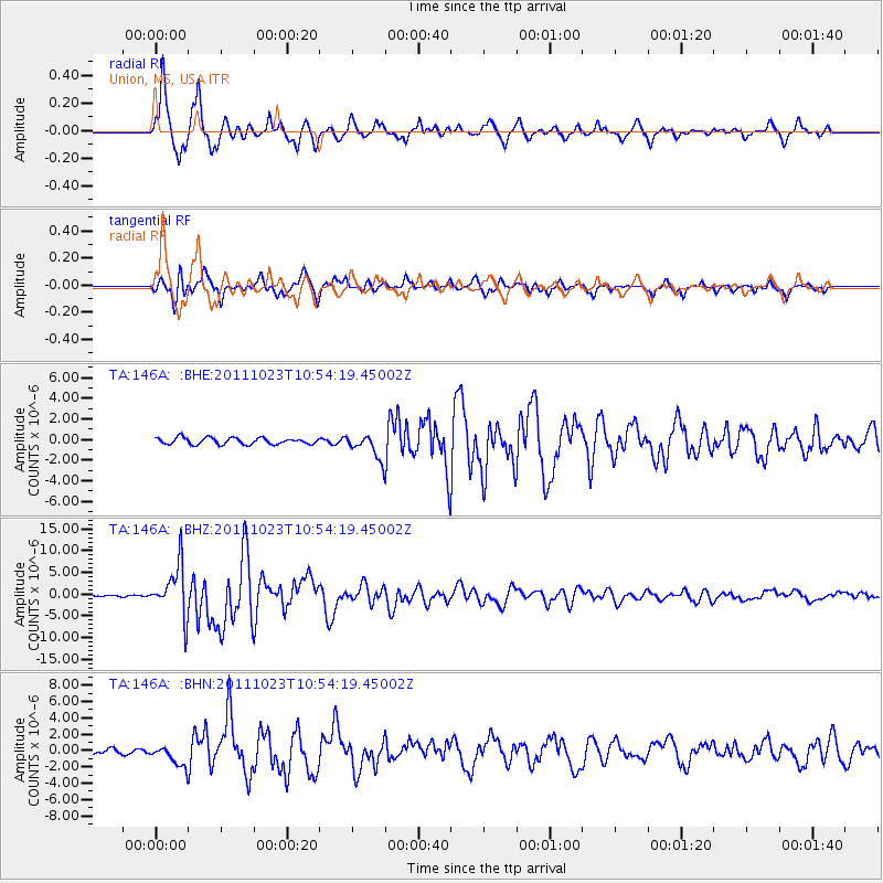
> Station 146A Union, MS, USA > Earthquake Result Viewer
146A Union, MS, USA - Earthquake Result Viewer
| Earthquake location: |
Turkey |
| Earthquake latitude/longitude: |
38.7/43.5 |
| Earthquake time(UTC): |
2011/10/23 (296) 10:41:22 GMT |
| Earthquake Depth: |
16 km |
| Earthquake Magnitude: |
6.9 MB, 7.3 MS, 7.3 MW, 7.1 MW |
| Earthquake Catalog/Contributor: |
WHDF/NEIC |
|
| Network: |
TA USArray Transportable Network (new EarthScope stations) |
| Station: |
146A Union, MS, USA |
| Lat/Lon: |
32.64 N/89.06 W |
| Elevation: |
164 m |
|
| Distance: |
96.4 deg |
| Az: |
321.295 deg |
| Baz: |
35.432 deg |
| Ray Param: |
0.040512223 |
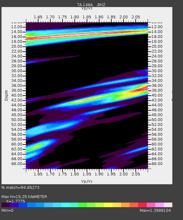
| Estimated Moho Depth: |
15.25 km |
| Estimated Crust Vp/Vs: |
1.78 |
| Assumed Crust Vp: |
6.201 km/s |
| Estimated Crust Vs: |
3.489 km/s |
| Estimated Crust Poisson's Ratio: |
0.27 |
|
| Radial Match: |
94.65273 % |
| Radial Bump: |
396 |
| Transverse Match: |
92.2597 % |
| Transverse Bump: |
400 |
| SOD ConfigId: |
424168 |
| Insert Time: |
2012-02-16 06:09:51.762 +0000 |
| GWidth: |
2.5 |
| Max Bumps: |
400 |
| Tol: |
0.001 |
|
Signal To Noise
| Channel | StoN | STA | LTA |
| TA:146A: :BHZ:20111023T10:54:19.45002Z | 33.30567 | 5.8037817E-6 | 1.7425806E-7 |
| TA:146A: :BHN:20111023T10:54:19.45002Z | 2.736584 | 1.2572971E-6 | 4.5944032E-7 |
| TA:146A: :BHE:20111023T10:54:19.45002Z | 3.8200815 | 1.2089326E-6 | 3.1646778E-7 |
| Arrivals |
| Ps | 1.9 SECOND |
| PpPs | 6.7 SECOND |
| PsPs/PpSs | 8.7 SECOND |


