You are here: Home > Network List > TA - USArray Transportable Network (new EarthScope stations) Stations List
> Station 348A Jackson, AL, USA > Earthquake Result Viewer
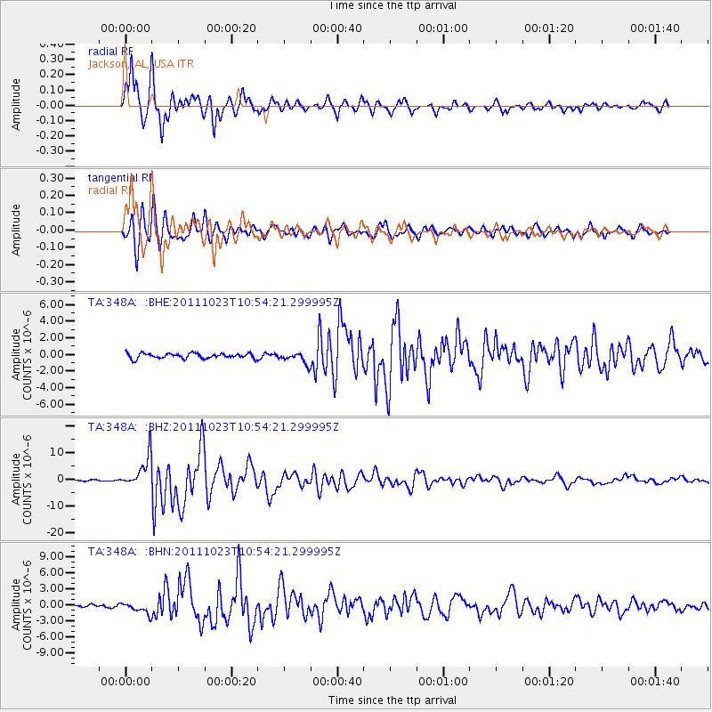
348A Jackson, AL, USA - Earthquake Result Viewer
*The percent match for this event was below the threshold and hence no stack was calculated.
| Earthquake location: |
Turkey |
| Earthquake latitude/longitude: |
38.7/43.5 |
| Earthquake time(UTC): |
2011/10/23 (296) 10:41:22 GMT |
| Earthquake Depth: |
16 km |
| Earthquake Magnitude: |
6.9 MB, 7.3 MS, 7.3 MW, 7.1 MW |
| Earthquake Catalog/Contributor: |
WHDF/NEIC |
|
| Network: |
TA USArray Transportable Network (new EarthScope stations) |
| Station: |
348A Jackson, AL, USA |
| Lat/Lon: |
31.41 N/87.90 W |
| Elevation: |
57 m |
|
| Distance: |
96.9 deg |
| Az: |
319.775 deg |
| Baz: |
36.217 deg |
| Ray Param: |
$rayparam |
*The percent match for this event was below the threshold and hence was not used in the summary stack. |
|
| Radial Match: |
97.34012 % |
| Radial Bump: |
331 |
| Transverse Match: |
94.04925 % |
| Transverse Bump: |
400 |
| SOD ConfigId: |
424168 |
| Insert Time: |
2012-02-16 06:10:26.523 +0000 |
| GWidth: |
2.5 |
| Max Bumps: |
400 |
| Tol: |
0.001 |
|
Signal To Noise
| Channel | StoN | STA | LTA |
| TA:348A: :BHZ:20111023T10:54:21.299995Z | 36.496914 | 5.938335E-6 | 1.6270786E-7 |
| TA:348A: :BHN:20111023T10:54:21.299995Z | 4.033752 | 1.021486E-6 | 2.532347E-7 |
| TA:348A: :BHE:20111023T10:54:21.299995Z | 2.196325 | 6.698686E-7 | 3.0499518E-7 |
| Arrivals |
| Ps | |
| PpPs | |
| PsPs/PpSs | |


