You are here: Home > Network List > TA - USArray Transportable Network (new EarthScope stations) Stations List
> Station Y43A Makayla and Karen, Gunnison, MS, USA > Earthquake Result Viewer
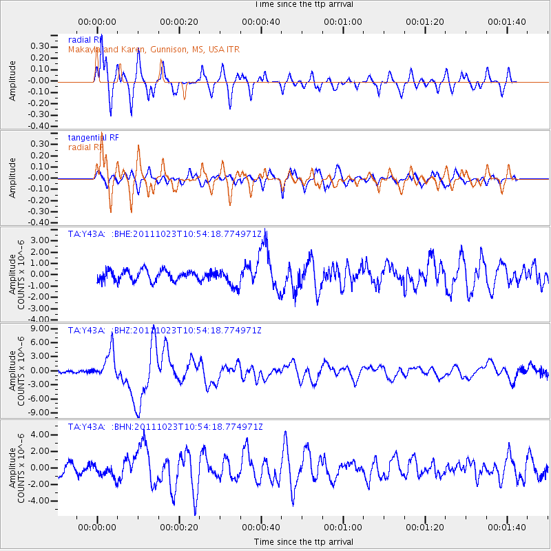
Y43A Makayla and Karen, Gunnison, MS, USA - Earthquake Result Viewer
*The percent match for this event was below the threshold and hence no stack was calculated.
| Earthquake location: |
Turkey |
| Earthquake latitude/longitude: |
38.7/43.5 |
| Earthquake time(UTC): |
2011/10/23 (296) 10:41:22 GMT |
| Earthquake Depth: |
16 km |
| Earthquake Magnitude: |
6.9 MB, 7.3 MS, 7.3 MW, 7.1 MW |
| Earthquake Catalog/Contributor: |
WHDF/NEIC |
|
| Network: |
TA USArray Transportable Network (new EarthScope stations) |
| Station: |
Y43A Makayla and Karen, Gunnison, MS, USA |
| Lat/Lon: |
33.91 N/90.93 W |
| Elevation: |
46 m |
|
| Distance: |
96.3 deg |
| Az: |
323.32 deg |
| Baz: |
34.185 deg |
| Ray Param: |
$rayparam |
*The percent match for this event was below the threshold and hence was not used in the summary stack. |
|
| Radial Match: |
88.421036 % |
| Radial Bump: |
361 |
| Transverse Match: |
74.866394 % |
| Transverse Bump: |
400 |
| SOD ConfigId: |
424168 |
| Insert Time: |
2012-02-16 06:11:00.376 +0000 |
| GWidth: |
2.5 |
| Max Bumps: |
400 |
| Tol: |
0.001 |
|
Signal To Noise
| Channel | StoN | STA | LTA |
| TA:Y43A: :BHZ:20111023T10:54:18.774971Z | 11.962109 | 3.198159E-6 | 2.6735745E-7 |
| TA:Y43A: :BHN:20111023T10:54:18.774971Z | 1.4051394 | 8.273759E-7 | 5.888212E-7 |
| TA:Y43A: :BHE:20111023T10:54:18.774971Z | 1.7087122 | 7.9105104E-7 | 4.629516E-7 |
| Arrivals |
| Ps | |
| PpPs | |
| PsPs/PpSs | |


