You are here: Home > Network List > TA - USArray Transportable Network (new EarthScope stations) Stations List
> Station P39B Salisbury, MO, USA > Earthquake Result Viewer
P39B Salisbury, MO, USA - Earthquake Result Viewer

| Earthquake location: |
Turkey |
| Earthquake latitude/longitude: |
38.7/43.5 |
| Earthquake time(UTC): |
2011/10/23 (296) 10:41:22 GMT |
| Earthquake Depth: |
16 km |
| Earthquake Magnitude: |
6.9 MB, 7.3 MS, 7.3 MW, 7.1 MW |
| Earthquake Catalog/Contributor: |
WHDF/NEIC |
|
| Network: |
TA USArray Transportable Network (new EarthScope stations) |
| Station: |
P39B Salisbury, MO, USA |
| Lat/Lon: |
39.49 N/92.75 W |
| Elevation: |
226 m |
|
| Distance: |
92.5 deg |
| Az: |
327.625 deg |
| Baz: |
32.769 deg |
| Ray Param: |
0.041452616 |
| Estimated Moho Depth: |
51.25 km |
| Estimated Crust Vp/Vs: |
1.89 |
| Assumed Crust Vp: |
6.498 km/s |
| Estimated Crust Vs: |
3.442 km/s |
| Estimated Crust Poisson's Ratio: |
0.30 |
|
| Radial Match: |
98.00251 % |
| Radial Bump: |
379 |
| Transverse Match: |
90.05978 % |
| Transverse Bump: |
400 |
| SOD ConfigId: |
424168 |
| Insert Time: |
2012-02-16 06:12:44.132 +0000 |
| GWidth: |
2.5 |
| Max Bumps: |
400 |
| Tol: |
0.001 |
|
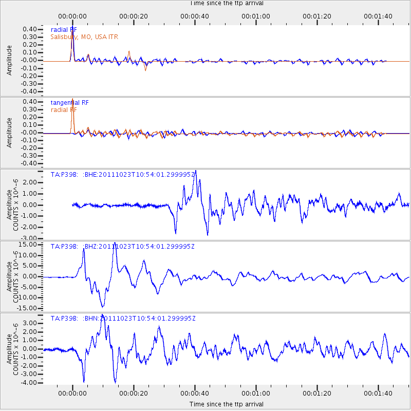
Signal To Noise
| Channel | StoN | STA | LTA |
| TA:P39B: :BHZ:20111023T10:54:01.299995Z | 59.128654 | 4.862334E-6 | 8.223312E-8 |
| TA:P39B: :BHN:20111023T10:54:01.299995Z | 10.344925 | 1.3443002E-6 | 1.299478E-7 |
| TA:P39B: :BHE:20111023T10:54:01.299995Z | 10.474592 | 8.659974E-7 | 8.2676E-8 |
| Arrivals |
| Ps | 7.1 SECOND |
| PpPs | 22 SECOND |
| PsPs/PpSs | 29 SECOND |


