You are here: Home > Network List > TA - USArray Transportable Network (new EarthScope stations) Stations List
> Station Q42A Golden Eagle, IL, USA > Earthquake Result Viewer
Q42A Golden Eagle, IL, USA - Earthquake Result Viewer

| Earthquake location: |
Turkey |
| Earthquake latitude/longitude: |
38.7/43.5 |
| Earthquake time(UTC): |
2011/10/23 (296) 10:41:22 GMT |
| Earthquake Depth: |
16 km |
| Earthquake Magnitude: |
6.9 MB, 7.3 MS, 7.3 MW, 7.1 MW |
| Earthquake Catalog/Contributor: |
WHDF/NEIC |
|
| Network: |
TA USArray Transportable Network (new EarthScope stations) |
| Station: |
Q42A Golden Eagle, IL, USA |
| Lat/Lon: |
38.91 N/90.53 W |
| Elevation: |
175 m |
|
| Distance: |
92.0 deg |
| Az: |
325.868 deg |
| Baz: |
34.235 deg |
| Ray Param: |
0.04152542 |
| Estimated Moho Depth: |
14.0 km |
| Estimated Crust Vp/Vs: |
1.99 |
| Assumed Crust Vp: |
6.498 km/s |
| Estimated Crust Vs: |
3.261 km/s |
| Estimated Crust Poisson's Ratio: |
0.33 |
|
| Radial Match: |
97.49137 % |
| Radial Bump: |
400 |
| Transverse Match: |
90.36087 % |
| Transverse Bump: |
400 |
| SOD ConfigId: |
424168 |
| Insert Time: |
2012-02-16 06:12:50.615 +0000 |
| GWidth: |
2.5 |
| Max Bumps: |
400 |
| Tol: |
0.001 |
|
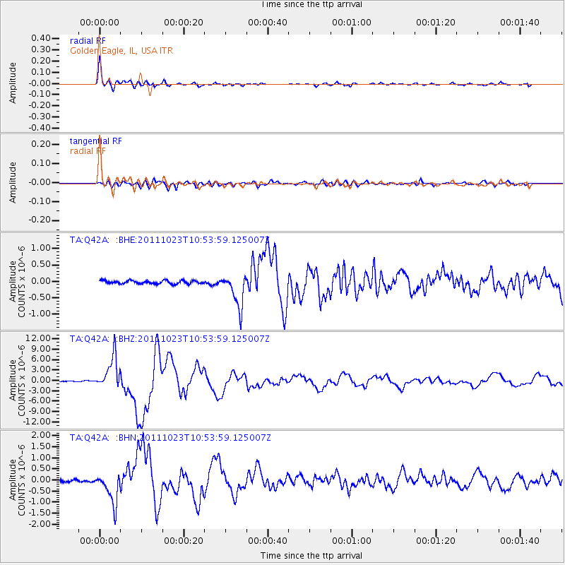
Signal To Noise
| Channel | StoN | STA | LTA |
| TA:Q42A: :BHZ:20111023T10:53:59.125007Z | 45.63447 | 4.7950575E-6 | 1.0507534E-7 |
| TA:Q42A: :BHN:20111023T10:53:59.125007Z | 12.690205 | 7.200058E-7 | 5.6737132E-8 |
| TA:Q42A: :BHE:20111023T10:53:59.125007Z | 10.819453 | 5.302618E-7 | 4.9010033E-8 |
| Arrivals |
| Ps | 2.2 SECOND |
| PpPs | 6.3 SECOND |
| PsPs/PpSs | 8.5 SECOND |


