You are here: Home > Network List > TA - USArray Transportable Network (new EarthScope stations) Stations List
> Station V44A Blytheville, AR, USA > Earthquake Result Viewer
V44A Blytheville, AR, USA - Earthquake Result Viewer
| Earthquake location: |
Turkey |
| Earthquake latitude/longitude: |
38.7/43.5 |
| Earthquake time(UTC): |
2011/10/23 (296) 10:41:22 GMT |
| Earthquake Depth: |
16 km |
| Earthquake Magnitude: |
6.9 MB, 7.3 MS, 7.3 MW, 7.1 MW |
| Earthquake Catalog/Contributor: |
WHDF/NEIC |
|
| Network: |
TA USArray Transportable Network (new EarthScope stations) |
| Station: |
V44A Blytheville, AR, USA |
| Lat/Lon: |
35.83 N/89.90 W |
| Elevation: |
78 m |
|
| Distance: |
94.2 deg |
| Az: |
323.703 deg |
| Baz: |
34.738 deg |
| Ray Param: |
0.041088913 |
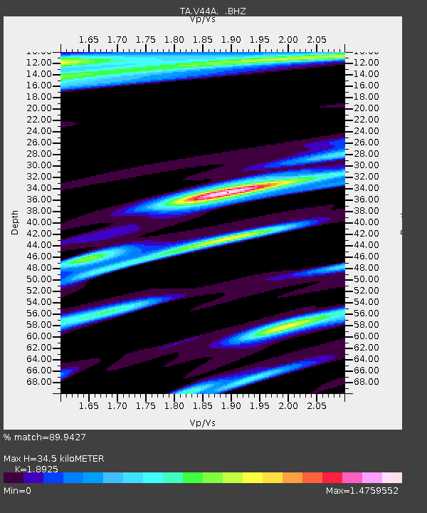
| Estimated Moho Depth: |
34.5 km |
| Estimated Crust Vp/Vs: |
1.89 |
| Assumed Crust Vp: |
6.38 km/s |
| Estimated Crust Vs: |
3.371 km/s |
| Estimated Crust Poisson's Ratio: |
0.31 |
|
| Radial Match: |
89.9427 % |
| Radial Bump: |
400 |
| Transverse Match: |
83.945274 % |
| Transverse Bump: |
400 |
| SOD ConfigId: |
424168 |
| Insert Time: |
2012-02-16 06:13:19.805 +0000 |
| GWidth: |
2.5 |
| Max Bumps: |
400 |
| Tol: |
0.001 |
|

Signal To Noise
| Channel | StoN | STA | LTA |
| TA:V44A: :BHZ:20111023T10:54:09.45002Z | 23.560837 | 4.3721984E-6 | 1.855706E-7 |
| TA:V44A: :BHN:20111023T10:54:09.45002Z | 2.0611405 | 1.0859212E-6 | 5.2685454E-7 |
| TA:V44A: :BHE:20111023T10:54:09.45002Z | 2.6412275 | 1.2519442E-6 | 4.740009E-7 |
| Arrivals |
| Ps | 4.9 SECOND |
| PpPs | 15 SECOND |
| PsPs/PpSs | 20 SECOND |


