You are here: Home > Network List > TA - USArray Transportable Network (new EarthScope stations) Stations List
> Station X43A Marvell, AR, USA > Earthquake Result Viewer
X43A Marvell, AR, USA - Earthquake Result Viewer
*The percent match for this event was below the threshold and hence no stack was calculated.
| Earthquake location: |
Turkey |
| Earthquake latitude/longitude: |
38.7/43.5 |
| Earthquake time(UTC): |
2011/10/23 (296) 10:41:22 GMT |
| Earthquake Depth: |
16 km |
| Earthquake Magnitude: |
6.9 MB, 7.3 MS, 7.3 MW, 7.1 MW |
| Earthquake Catalog/Contributor: |
WHDF/NEIC |
|
| Network: |
TA USArray Transportable Network (new EarthScope stations) |
| Station: |
X43A Marvell, AR, USA |
| Lat/Lon: |
34.52 N/90.88 W |
| Elevation: |
53 m |
|
| Distance: |
95.8 deg |
| Az: |
323.629 deg |
| Baz: |
34.179 deg |
| Ray Param: |
$rayparam |
*The percent match for this event was below the threshold and hence was not used in the summary stack. |
|
| Radial Match: |
86.69093 % |
| Radial Bump: |
400 |
| Transverse Match: |
79.722984 % |
| Transverse Bump: |
400 |
| SOD ConfigId: |
424168 |
| Insert Time: |
2012-02-16 06:13:48.593 +0000 |
| GWidth: |
2.5 |
| Max Bumps: |
400 |
| Tol: |
0.001 |
|
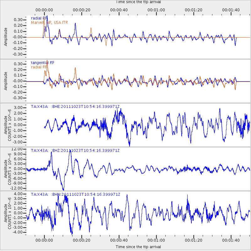
Signal To Noise
| Channel | StoN | STA | LTA |
| TA:X43A: :BHZ:20111023T10:54:16.399971Z | 9.355237 | 3.9166357E-6 | 4.18657E-7 |
| TA:X43A: :BHN:20111023T10:54:16.399971Z | 2.1452923 | 1.3567725E-6 | 6.324418E-7 |
| TA:X43A: :BHE:20111023T10:54:16.399971Z | 1.5410355 | 9.682825E-7 | 6.283324E-7 |
| Arrivals |
| Ps | |
| PpPs | |
| PsPs/PpSs | |


