You are here: Home > Network List > G - GEOSCOPE Stations List
> Station HYB Hyderabad, India > Earthquake Result Viewer
HYB Hyderabad, India - Earthquake Result Viewer

| Earthquake location: |
Bonin Islands, Japan Region |
| Earthquake latitude/longitude: |
28.1/139.6 |
| Earthquake time(UTC): |
1991/05/03 (123) 02:14:17 GMT |
| Earthquake Depth: |
459 km |
| Earthquake Magnitude: |
6.0 MB, 6.0 UNKNOWN |
| Earthquake Catalog/Contributor: |
WHDF/NEIC |
|
| Network: |
G GEOSCOPE |
| Station: |
HYB Hyderabad, India |
| Lat/Lon: |
17.42 N/78.55 E |
| Elevation: |
510 m |
|
| Distance: |
56.8 deg |
| Az: |
273.182 deg |
| Baz: |
67.554 deg |
| Ray Param: |
0.062141925 |
| Estimated Moho Depth: |
34.0 km |
| Estimated Crust Vp/Vs: |
1.69 |
| Assumed Crust Vp: |
6.459 km/s |
| Estimated Crust Vs: |
3.822 km/s |
| Estimated Crust Poisson's Ratio: |
0.23 |
|
| Radial Match: |
94.95925 % |
| Radial Bump: |
400 |
| Transverse Match: |
75.49807 % |
| Transverse Bump: |
400 |
| SOD ConfigId: |
4480 |
| Insert Time: |
2010-02-26 22:38:48.479 +0000 |
| GWidth: |
2.5 |
| Max Bumps: |
400 |
| Tol: |
0.001 |
|
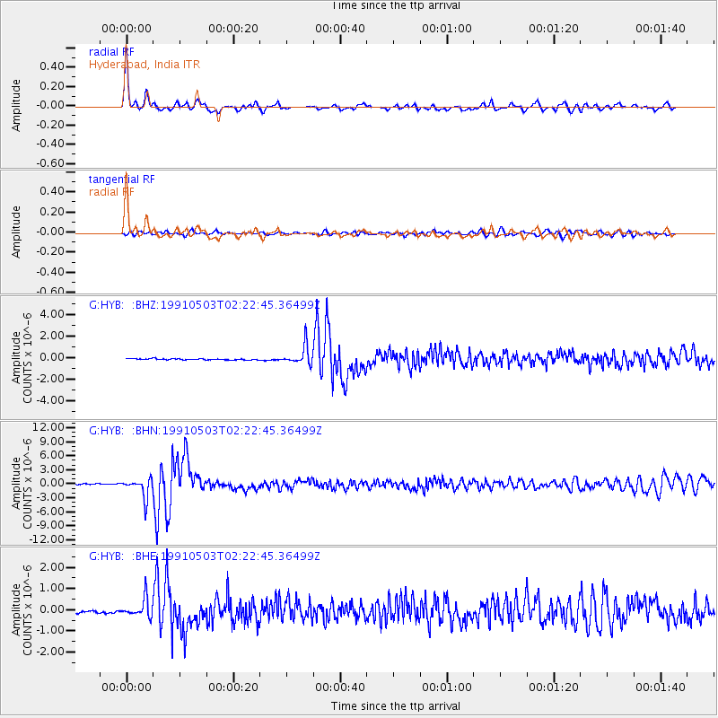
Signal To Noise
| Channel | StoN | STA | LTA |
| G:HYB: :BHN:19910503T02:22:45.36499Z | 24.741428 | 2.0799514E-6 | 8.406755E-8 |
| G:HYB: :BHE:19910503T02:22:45.36499Z | 7.283698 | 4.4181093E-7 | 6.06575E-8 |
| G:HYB: :BHZ:19910503T02:22:45.36499Z | 16.08245 | 8.742713E-7 | 5.4361823E-8 |
| Arrivals |
| Ps | 3.8 SECOND |
| PpPs | 13 SECOND |
| PsPs/PpSs | 17 SECOND |


