You are here: Home > Network List > TA - USArray Transportable Network (new EarthScope stations) Stations List
> Station K40A Colesburg, IA, USA > Earthquake Result Viewer
K40A Colesburg, IA, USA - Earthquake Result Viewer
| Earthquake location: |
Turkey |
| Earthquake latitude/longitude: |
38.7/43.5 |
| Earthquake time(UTC): |
2011/10/23 (296) 10:41:22 GMT |
| Earthquake Depth: |
16 km |
| Earthquake Magnitude: |
6.9 MB, 7.3 MS, 7.3 MW, 7.1 MW |
| Earthquake Catalog/Contributor: |
WHDF/NEIC |
|
| Network: |
TA USArray Transportable Network (new EarthScope stations) |
| Station: |
K40A Colesburg, IA, USA |
| Lat/Lon: |
42.70 N/91.14 W |
| Elevation: |
274 m |
|
| Distance: |
89.1 deg |
| Az: |
328.366 deg |
| Baz: |
33.817 deg |
| Ray Param: |
0.042085554 |
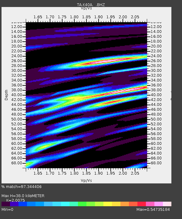
| Estimated Moho Depth: |
38.0 km |
| Estimated Crust Vp/Vs: |
2.01 |
| Assumed Crust Vp: |
6.53 km/s |
| Estimated Crust Vs: |
3.253 km/s |
| Estimated Crust Poisson's Ratio: |
0.33 |
|
| Radial Match: |
97.344406 % |
| Radial Bump: |
364 |
| Transverse Match: |
87.920815 % |
| Transverse Bump: |
400 |
| SOD ConfigId: |
424168 |
| Insert Time: |
2012-02-16 06:14:59.031 +0000 |
| GWidth: |
2.5 |
| Max Bumps: |
400 |
| Tol: |
0.001 |
|

Signal To Noise
| Channel | StoN | STA | LTA |
| TA:K40A: :BHZ:20111023T10:53:45.799995Z | 38.68003 | 6.3142197E-6 | 1.6324236E-7 |
| TA:K40A: :BHN:20111023T10:53:45.799995Z | 13.814991 | 2.007095E-6 | 1.4528383E-7 |
| TA:K40A: :BHE:20111023T10:53:45.799995Z | 12.029907 | 1.1927647E-6 | 9.914994E-8 |
| Arrivals |
| Ps | 6.0 SECOND |
| PpPs | 17 SECOND |
| PsPs/PpSs | 23 SECOND |


