You are here: Home > Network List > TA - USArray Transportable Network (new EarthScope stations) Stations List
> Station K39A Oelwein, IA, USA > Earthquake Result Viewer
K39A Oelwein, IA, USA - Earthquake Result Viewer
| Earthquake location: |
Turkey |
| Earthquake latitude/longitude: |
38.7/43.5 |
| Earthquake time(UTC): |
2011/10/23 (296) 10:41:22 GMT |
| Earthquake Depth: |
16 km |
| Earthquake Magnitude: |
6.9 MB, 7.3 MS, 7.3 MW, 7.1 MW |
| Earthquake Catalog/Contributor: |
WHDF/NEIC |
|
| Network: |
TA USArray Transportable Network (new EarthScope stations) |
| Station: |
K39A Oelwein, IA, USA |
| Lat/Lon: |
42.71 N/91.89 W |
| Elevation: |
332 m |
|
| Distance: |
89.4 deg |
| Az: |
328.829 deg |
| Baz: |
33.317 deg |
| Ray Param: |
0.04186599 |
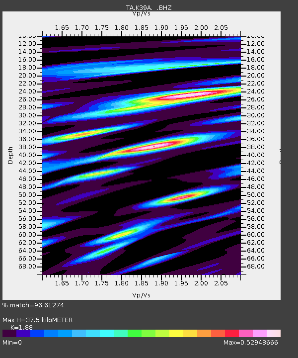
| Estimated Moho Depth: |
37.5 km |
| Estimated Crust Vp/Vs: |
1.88 |
| Assumed Crust Vp: |
6.53 km/s |
| Estimated Crust Vs: |
3.474 km/s |
| Estimated Crust Poisson's Ratio: |
0.30 |
|
| Radial Match: |
96.61274 % |
| Radial Bump: |
400 |
| Transverse Match: |
88.31255 % |
| Transverse Bump: |
400 |
| SOD ConfigId: |
424168 |
| Insert Time: |
2012-02-16 06:15:06.753 +0000 |
| GWidth: |
2.5 |
| Max Bumps: |
400 |
| Tol: |
0.001 |
|
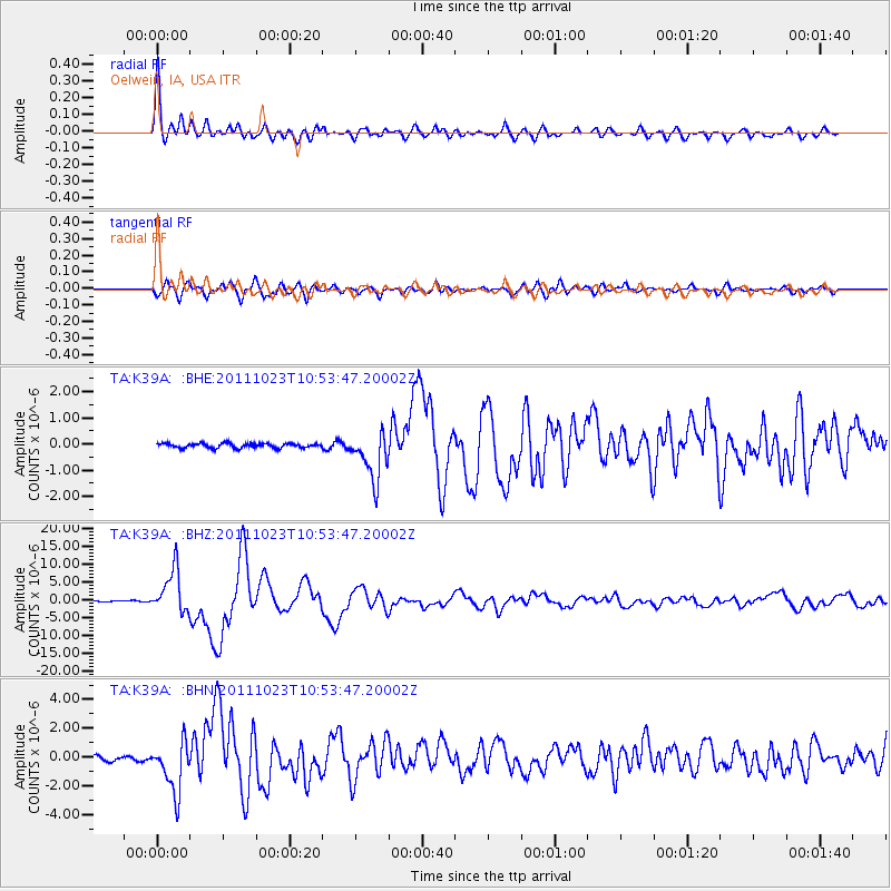
Signal To Noise
| Channel | StoN | STA | LTA |
| TA:K39A: :BHZ:20111023T10:53:47.20002Z | 58.10493 | 6.058269E-6 | 1.0426428E-7 |
| TA:K39A: :BHN:20111023T10:53:47.20002Z | 14.594734 | 1.7588288E-6 | 1.2051119E-7 |
| TA:K39A: :BHE:20111023T10:53:47.20002Z | 10.501138 | 9.17133E-7 | 8.733654E-8 |
| Arrivals |
| Ps | 5.2 SECOND |
| PpPs | 16 SECOND |
| PsPs/PpSs | 21 SECOND |


