You are here: Home > Network List > TA - USArray Transportable Network (new EarthScope stations) Stations List
> Station R41A Rosebud, MO, USA > Earthquake Result Viewer
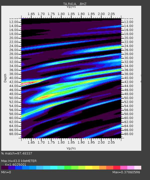
R41A Rosebud, MO, USA - Earthquake Result Viewer
| Earthquake location: |
Turkey |
| Earthquake latitude/longitude: |
38.7/43.5 |
| Earthquake time(UTC): |
2011/10/23 (296) 10:41:22 GMT |
| Earthquake Depth: |
16 km |
| Earthquake Magnitude: |
6.9 MB, 7.3 MS, 7.3 MW, 7.1 MW |
| Earthquake Catalog/Contributor: |
WHDF/NEIC |
|
| Network: |
TA USArray Transportable Network (new EarthScope stations) |
| Station: |
R41A Rosebud, MO, USA |
| Lat/Lon: |
38.30 N/91.38 W |
| Elevation: |
257 m |
|
| Distance: |
92.9 deg |
| Az: |
326.075 deg |
| Baz: |
33.701 deg |
| Ray Param: |
0.04137234 |
| Estimated Moho Depth: |
43.0 km |
| Estimated Crust Vp/Vs: |
1.60 |
| Assumed Crust Vp: |
6.498 km/s |
| Estimated Crust Vs: |
4.055 km/s |
| Estimated Crust Poisson's Ratio: |
0.18 |
|
| Radial Match: |
97.48337 % |
| Radial Bump: |
400 |
| Transverse Match: |
84.10224 % |
| Transverse Bump: |
400 |
| SOD ConfigId: |
424168 |
| Insert Time: |
2012-02-16 06:16:56.103 +0000 |
| GWidth: |
2.5 |
| Max Bumps: |
400 |
| Tol: |
0.001 |
|

Signal To Noise
| Channel | StoN | STA | LTA |
| TA:R41A: :BHZ:20111023T10:54:03.174995Z | 41.748142 | 4.137677E-6 | 9.911045E-8 |
| TA:R41A: :BHN:20111023T10:54:03.174995Z | 10.410798 | 1.2271071E-6 | 1.1786869E-7 |
| TA:R41A: :BHE:20111023T10:54:03.174995Z | 10.163254 | 8.53391E-7 | 8.396829E-8 |
| Arrivals |
| Ps | 4.1 SECOND |
| PpPs | 17 SECOND |
| PsPs/PpSs | 21 SECOND |


