You are here: Home > Network List > TA - USArray Transportable Network (new EarthScope stations) Stations List
> Station U43A Rector, AR, USA > Earthquake Result Viewer
U43A Rector, AR, USA - Earthquake Result Viewer
| Earthquake location: |
Turkey |
| Earthquake latitude/longitude: |
38.7/43.5 |
| Earthquake time(UTC): |
2011/10/23 (296) 10:41:22 GMT |
| Earthquake Depth: |
16 km |
| Earthquake Magnitude: |
6.9 MB, 7.3 MS, 7.3 MW, 7.1 MW |
| Earthquake Catalog/Contributor: |
WHDF/NEIC |
|
| Network: |
TA USArray Transportable Network (new EarthScope stations) |
| Station: |
U43A Rector, AR, USA |
| Lat/Lon: |
36.37 N/90.41 W |
| Elevation: |
96 m |
|
| Distance: |
94.0 deg |
| Az: |
324.351 deg |
| Baz: |
34.392 deg |
| Ray Param: |
0.041137703 |
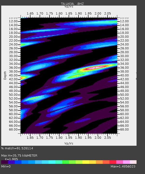
| Estimated Moho Depth: |
35.75 km |
| Estimated Crust Vp/Vs: |
1.99 |
| Assumed Crust Vp: |
6.53 km/s |
| Estimated Crust Vs: |
3.29 km/s |
| Estimated Crust Poisson's Ratio: |
0.33 |
|
| Radial Match: |
91.528114 % |
| Radial Bump: |
400 |
| Transverse Match: |
66.21436 % |
| Transverse Bump: |
400 |
| SOD ConfigId: |
424168 |
| Insert Time: |
2012-02-16 06:17:14.336 +0000 |
| GWidth: |
2.5 |
| Max Bumps: |
400 |
| Tol: |
0.001 |
|

Signal To Noise
| Channel | StoN | STA | LTA |
| TA:U43A: :BHZ:20111023T10:54:08.474983Z | 36.73555 | 3.838737E-6 | 1.04496515E-7 |
| TA:U43A: :BHN:20111023T10:54:08.474983Z | 9.613454 | 1.5653862E-6 | 1.6283286E-7 |
| TA:U43A: :BHE:20111023T10:54:08.474983Z | 6.418927 | 1.2802839E-6 | 1.9945449E-7 |
| Arrivals |
| Ps | 5.5 SECOND |
| PpPs | 16 SECOND |
| PsPs/PpSs | 22 SECOND |


