You are here: Home > Network List > TA - USArray Transportable Network (new EarthScope stations) Stations List
> Station W43A Forest City, AR, USA > Earthquake Result Viewer
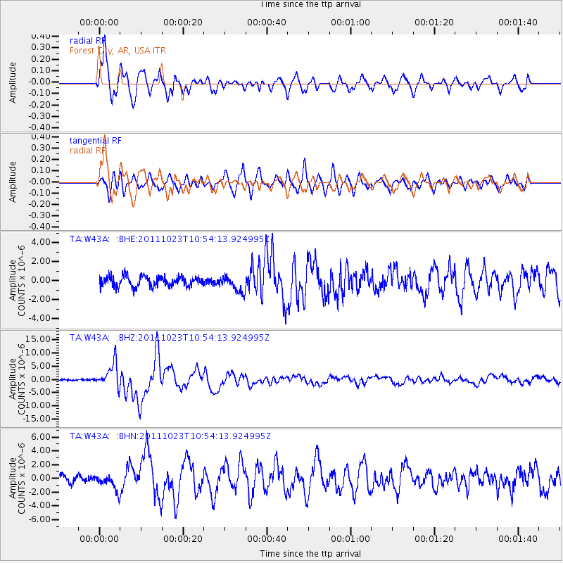
W43A Forest City, AR, USA - Earthquake Result Viewer
*The percent match for this event was below the threshold and hence no stack was calculated.
| Earthquake location: |
Turkey |
| Earthquake latitude/longitude: |
38.7/43.5 |
| Earthquake time(UTC): |
2011/10/23 (296) 10:41:22 GMT |
| Earthquake Depth: |
16 km |
| Earthquake Magnitude: |
6.9 MB, 7.3 MS, 7.3 MW, 7.1 MW |
| Earthquake Catalog/Contributor: |
WHDF/NEIC |
|
| Network: |
TA USArray Transportable Network (new EarthScope stations) |
| Station: |
W43A Forest City, AR, USA |
| Lat/Lon: |
35.09 N/90.71 W |
| Elevation: |
70 m |
|
| Distance: |
95.2 deg |
| Az: |
323.83 deg |
| Baz: |
34.259 deg |
| Ray Param: |
$rayparam |
*The percent match for this event was below the threshold and hence was not used in the summary stack. |
|
| Radial Match: |
94.137024 % |
| Radial Bump: |
400 |
| Transverse Match: |
83.92814 % |
| Transverse Bump: |
400 |
| SOD ConfigId: |
424168 |
| Insert Time: |
2012-02-16 06:17:38.969 +0000 |
| GWidth: |
2.5 |
| Max Bumps: |
400 |
| Tol: |
0.001 |
|
Signal To Noise
| Channel | StoN | STA | LTA |
| TA:W43A: :BHZ:20111023T10:54:13.924995Z | 19.962477 | 4.628625E-6 | 2.3186627E-7 |
| TA:W43A: :BHN:20111023T10:54:13.924995Z | 2.2000463 | 1.1664711E-6 | 5.3020295E-7 |
| TA:W43A: :BHE:20111023T10:54:13.924995Z | 1.6748369 | 8.743755E-7 | 5.2206605E-7 |
| Arrivals |
| Ps | |
| PpPs | |
| PsPs/PpSs | |


