You are here: Home > Network List > TA - USArray Transportable Network (new EarthScope stations) Stations List
> Station I40A Norwalk, WI, USA > Earthquake Result Viewer
I40A Norwalk, WI, USA - Earthquake Result Viewer
| Earthquake location: |
Turkey |
| Earthquake latitude/longitude: |
38.7/43.5 |
| Earthquake time(UTC): |
2011/10/23 (296) 10:41:22 GMT |
| Earthquake Depth: |
16 km |
| Earthquake Magnitude: |
6.9 MB, 7.3 MS, 7.3 MW, 7.1 MW |
| Earthquake Catalog/Contributor: |
WHDF/NEIC |
|
| Network: |
TA USArray Transportable Network (new EarthScope stations) |
| Station: |
I40A Norwalk, WI, USA |
| Lat/Lon: |
43.89 N/90.62 W |
| Elevation: |
419 m |
|
| Distance: |
87.9 deg |
| Az: |
328.717 deg |
| Baz: |
34.182 deg |
| Ray Param: |
0.042975213 |
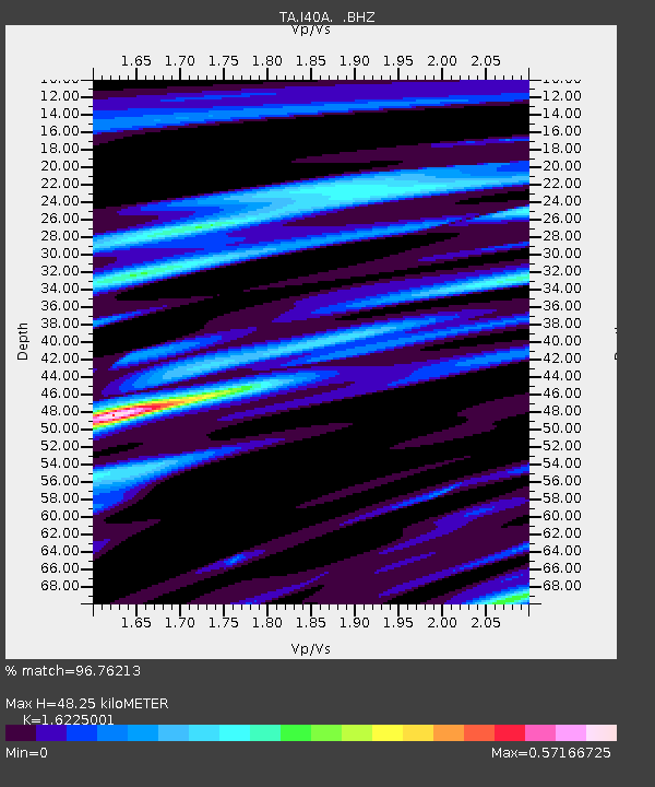
| Estimated Moho Depth: |
48.25 km |
| Estimated Crust Vp/Vs: |
1.62 |
| Assumed Crust Vp: |
6.53 km/s |
| Estimated Crust Vs: |
4.025 km/s |
| Estimated Crust Poisson's Ratio: |
0.19 |
|
| Radial Match: |
96.76213 % |
| Radial Bump: |
396 |
| Transverse Match: |
91.276024 % |
| Transverse Bump: |
400 |
| SOD ConfigId: |
424168 |
| Insert Time: |
2012-02-16 06:18:00.290 +0000 |
| GWidth: |
2.5 |
| Max Bumps: |
400 |
| Tol: |
0.001 |
|

Signal To Noise
| Channel | StoN | STA | LTA |
| TA:I40A: :BHZ:20111023T10:53:40.125007Z | 53.815323 | 7.71727E-6 | 1.4340283E-7 |
| TA:I40A: :BHN:20111023T10:53:40.125007Z | 24.282888 | 1.8027931E-6 | 7.424129E-8 |
| TA:I40A: :BHE:20111023T10:53:40.125007Z | 19.922646 | 1.6030871E-6 | 8.046557E-8 |
| Arrivals |
| Ps | 4.7 SECOND |
| PpPs | 19 SECOND |
| PsPs/PpSs | 24 SECOND |


