You are here: Home > Network List > TA - USArray Transportable Network (new EarthScope stations) Stations List
> Station U44B Burton Farm, Hornbeak, TN, USA > Earthquake Result Viewer
U44B Burton Farm, Hornbeak, TN, USA - Earthquake Result Viewer
| Earthquake location: |
Turkey |
| Earthquake latitude/longitude: |
38.7/43.5 |
| Earthquake time(UTC): |
2011/10/23 (296) 10:41:22 GMT |
| Earthquake Depth: |
16 km |
| Earthquake Magnitude: |
6.9 MB, 7.3 MS, 7.3 MW, 7.1 MW |
| Earthquake Catalog/Contributor: |
WHDF/NEIC |
|
| Network: |
TA USArray Transportable Network (new EarthScope stations) |
| Station: |
U44B Burton Farm, Hornbeak, TN, USA |
| Lat/Lon: |
36.34 N/89.35 W |
| Elevation: |
136 m |
|
| Distance: |
93.6 deg |
| Az: |
323.633 deg |
| Baz: |
35.062 deg |
| Ray Param: |
0.04123393 |
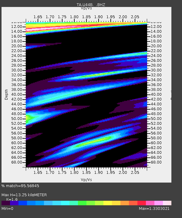
| Estimated Moho Depth: |
13.25 km |
| Estimated Crust Vp/Vs: |
1.60 |
| Assumed Crust Vp: |
6.444 km/s |
| Estimated Crust Vs: |
4.027 km/s |
| Estimated Crust Poisson's Ratio: |
0.18 |
|
| Radial Match: |
95.56945 % |
| Radial Bump: |
400 |
| Transverse Match: |
87.03047 % |
| Transverse Bump: |
400 |
| SOD ConfigId: |
424168 |
| Insert Time: |
2012-02-16 06:18:21.820 +0000 |
| GWidth: |
2.5 |
| Max Bumps: |
400 |
| Tol: |
0.001 |
|

Signal To Noise
| Channel | StoN | STA | LTA |
| TA:U44B: :BHZ:20111023T10:54:06.375007Z | 33.54522 | 6.766934E-6 | 2.0172573E-7 |
| TA:U44B: :BHN:20111023T10:54:06.375007Z | 3.245514 | 1.661441E-6 | 5.119192E-7 |
| TA:U44B: :BHE:20111023T10:54:06.375007Z | 2.7820039 | 1.3976038E-6 | 5.0237304E-7 |
| Arrivals |
| Ps | 1.3 SECOND |
| PpPs | 5.2 SECOND |
| PsPs/PpSs | 6.5 SECOND |


