You are here: Home > Network List > TA - USArray Transportable Network (new EarthScope stations) Stations List
> Station E40A Wakefield, MI, USA > Earthquake Result Viewer
E40A Wakefield, MI, USA - Earthquake Result Viewer
| Earthquake location: |
Turkey |
| Earthquake latitude/longitude: |
38.7/43.5 |
| Earthquake time(UTC): |
2011/10/23 (296) 10:41:22 GMT |
| Earthquake Depth: |
16 km |
| Earthquake Magnitude: |
6.9 MB, 7.3 MS, 7.3 MW, 7.1 MW |
| Earthquake Catalog/Contributor: |
WHDF/NEIC |
|
| Network: |
TA USArray Transportable Network (new EarthScope stations) |
| Station: |
E40A Wakefield, MI, USA |
| Lat/Lon: |
46.44 N/89.90 W |
| Elevation: |
472 m |
|
| Distance: |
85.5 deg |
| Az: |
329.744 deg |
| Baz: |
34.749 deg |
| Ray Param: |
0.04470319 |
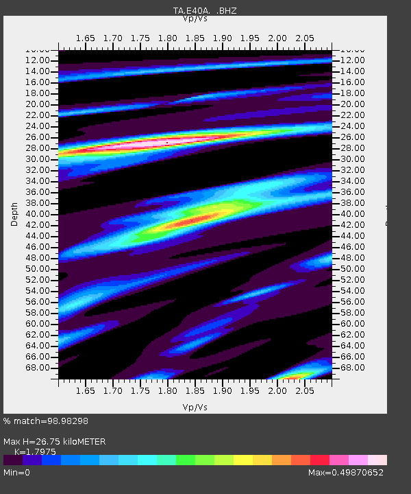
| Estimated Moho Depth: |
26.75 km |
| Estimated Crust Vp/Vs: |
1.80 |
| Assumed Crust Vp: |
6.467 km/s |
| Estimated Crust Vs: |
3.598 km/s |
| Estimated Crust Poisson's Ratio: |
0.28 |
|
| Radial Match: |
98.98298 % |
| Radial Bump: |
225 |
| Transverse Match: |
96.64655 % |
| Transverse Bump: |
400 |
| SOD ConfigId: |
424168 |
| Insert Time: |
2012-02-16 06:21:01.239 +0000 |
| GWidth: |
2.5 |
| Max Bumps: |
400 |
| Tol: |
0.001 |
|

Signal To Noise
| Channel | StoN | STA | LTA |
| TA:E40A: :BHZ:20111023T10:53:28.474983Z | 92.986374 | 1.0837331E-5 | 1.1654752E-7 |
| TA:E40A: :BHN:20111023T10:53:28.474983Z | 28.000738 | 3.2084906E-6 | 1.1458593E-7 |
| TA:E40A: :BHE:20111023T10:53:28.474983Z | 23.671394 | 2.22989E-6 | 9.420189E-8 |
| Arrivals |
| Ps | 3.4 SECOND |
| PpPs | 11 SECOND |
| PsPs/PpSs | 15 SECOND |


