You are here: Home > Network List > TA - USArray Transportable Network (new EarthScope stations) Stations List
> Station F45A CMU Biological Station, Beaver Island, MI, USA > Earthquake Result Viewer
F45A CMU Biological Station, Beaver Island, MI, USA - Earthquake Result Viewer

| Earthquake location: |
Turkey |
| Earthquake latitude/longitude: |
38.7/43.5 |
| Earthquake time(UTC): |
2011/10/23 (296) 10:41:22 GMT |
| Earthquake Depth: |
16 km |
| Earthquake Magnitude: |
6.9 MB, 7.3 MS, 7.3 MW, 7.1 MW |
| Earthquake Catalog/Contributor: |
WHDF/NEIC |
|
| Network: |
TA USArray Transportable Network (new EarthScope stations) |
| Station: |
F45A CMU Biological Station, Beaver Island, MI, USA |
| Lat/Lon: |
45.68 N/85.52 W |
| Elevation: |
173 m |
|
| Distance: |
84.3 deg |
| Az: |
326.821 deg |
| Baz: |
37.637 deg |
| Ray Param: |
0.04555724 |
| Estimated Moho Depth: |
48.75 km |
| Estimated Crust Vp/Vs: |
1.76 |
| Assumed Crust Vp: |
6.483 km/s |
| Estimated Crust Vs: |
3.673 km/s |
| Estimated Crust Poisson's Ratio: |
0.26 |
|
| Radial Match: |
98.16461 % |
| Radial Bump: |
400 |
| Transverse Match: |
93.88266 % |
| Transverse Bump: |
400 |
| SOD ConfigId: |
424168 |
| Insert Time: |
2012-02-16 06:22:06.523 +0000 |
| GWidth: |
2.5 |
| Max Bumps: |
400 |
| Tol: |
0.001 |
|
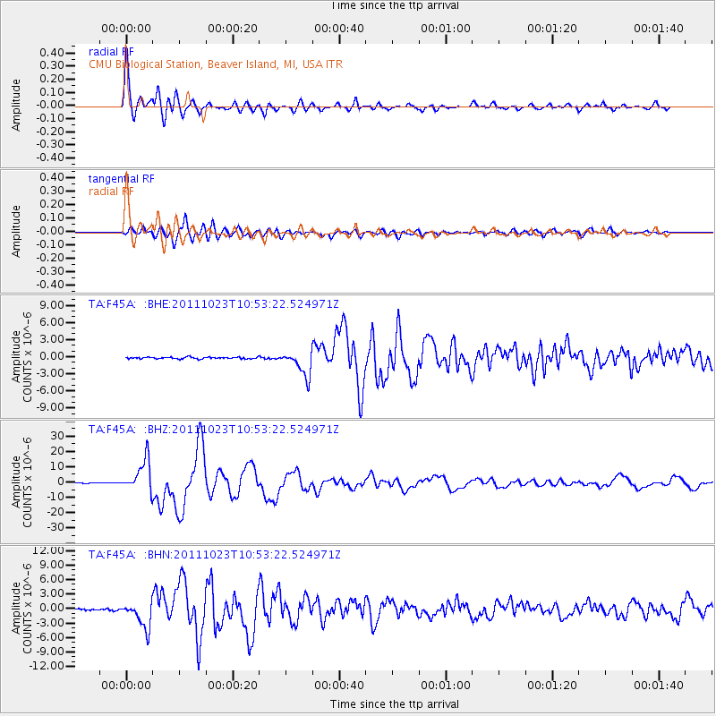
Signal To Noise
| Channel | StoN | STA | LTA |
| TA:F45A: :BHZ:20111023T10:53:22.524971Z | 80.56966 | 1.0541974E-5 | 1.3084298E-7 |
| TA:F45A: :BHN:20111023T10:53:22.524971Z | 18.01329 | 2.740334E-6 | 1.5212845E-7 |
| TA:F45A: :BHE:20111023T10:53:22.524971Z | 15.686414 | 2.1987087E-6 | 1.4016643E-7 |
| Arrivals |
| Ps | 5.9 SECOND |
| PpPs | 20 SECOND |
| PsPs/PpSs | 26 SECOND |


