You are here: Home > Network List > TA - USArray Transportable Network (new EarthScope stations) Stations List
> Station J43A Natural Harvest Farm, Hartford, WI, USA > Earthquake Result Viewer
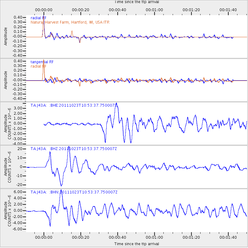
J43A Natural Harvest Farm, Hartford, WI, USA - Earthquake Result Viewer
| Earthquake location: |
Turkey |
| Earthquake latitude/longitude: |
38.7/43.5 |
| Earthquake time(UTC): |
2011/10/23 (296) 10:41:22 GMT |
| Earthquake Depth: |
16 km |
| Earthquake Magnitude: |
6.9 MB, 7.3 MS, 7.3 MW, 7.1 MW |
| Earthquake Catalog/Contributor: |
WHDF/NEIC |
|
| Network: |
TA USArray Transportable Network (new EarthScope stations) |
| Station: |
J43A Natural Harvest Farm, Hartford, WI, USA |
| Lat/Lon: |
43.38 N/88.42 W |
| Elevation: |
322 m |
|
| Distance: |
87.4 deg |
| Az: |
327.114 deg |
| Baz: |
35.629 deg |
| Ray Param: |
0.043337837 |
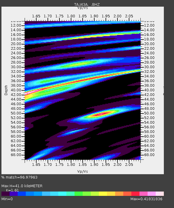
| Estimated Moho Depth: |
41.0 km |
| Estimated Crust Vp/Vs: |
1.61 |
| Assumed Crust Vp: |
6.571 km/s |
| Estimated Crust Vs: |
4.081 km/s |
| Estimated Crust Poisson's Ratio: |
0.19 |
|
| Radial Match: |
96.97963 % |
| Radial Bump: |
353 |
| Transverse Match: |
89.09528 % |
| Transverse Bump: |
400 |
| SOD ConfigId: |
424168 |
| Insert Time: |
2012-02-16 06:22:55.853 +0000 |
| GWidth: |
2.5 |
| Max Bumps: |
400 |
| Tol: |
0.001 |
|
Signal To Noise
| Channel | StoN | STA | LTA |
| TA:J43A: :BHZ:20111023T10:53:37.750007Z | 59.98202 | 6.9637226E-6 | 1.16096835E-7 |
| TA:J43A: :BHN:20111023T10:53:37.750007Z | 19.629475 | 1.8664585E-6 | 9.508449E-8 |
| TA:J43A: :BHE:20111023T10:53:37.750007Z | 10.612863 | 1.4029372E-6 | 1.3219216E-7 |
| Arrivals |
| Ps | 3.9 SECOND |
| PpPs | 16 SECOND |
| PsPs/PpSs | 20 SECOND |


