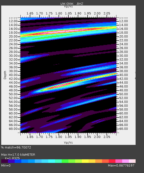
GNW Green Mountain (BB) - Earthquake Result Viewer

Earthquake location: Turkey
Earthquake latitude/longitude: 38.7/43.5
Earthquake time(UTC): 2011/10/23 (296) 10:41:22 GMT
Earthquake Depth: 16 km
Earthquake Magnitude: 6.9 MB, 7.3 MS, 7.3 MW, 7.1 MW
Earthquake Catalog/Contributor: WHDF/NEIC
Network: UW Pacific Northwest Regional Seismic Network
Station: GNW Green Mountain (BB)
Lat/Lon: 47.56 N/122.83 W
Elevation: 160 m
Distance: 93.2 deg
Az: 350.781 deg
Baz: 10.664 deg
Ray Param: 0.041298725
Estimated Moho Depth: 17.0 km
Estimated Crust Vp/Vs: 1.83
Assumed Crust Vp: 6.566 km/s
Estimated Crust Vs: 3.583 km/s
Estimated Crust Poisson's Ratio: 0.29
Radial Match: 96.70072 %
Radial Bump: 400
Transverse Match: 92.36555 %
Transverse Bump: 400
SOD ConfigId: 424168
Insert Time: 2012-02-16 06:25:09.783 +0000
GWidth: 2.5
Max Bumps: 400
Tol: 0.001

Signal To Noise

ChannelStoNSTALTA
UW:GNW: :BHZ:20111023T10:54:04.890022Z24.2604644.693765E-61.9347384E-7
UW:GNW: :BHN:20111023T10:54:04.890022Z4.9222081.1391971E-62.3144028E-7
UW:GNW: :BHE:20111023T10:54:04.890022Z3.59430934.7896594E-71.3325675E-7
Arrivals
Ps2.2 SECOND
PpPs7.2 SECOND
PsPs/PpSs9.4 SECOND