You are here: Home > Network List > G - GEOSCOPE Stations List
> Station HYB Hyderabad, India > Earthquake Result Viewer
HYB Hyderabad, India - Earthquake Result Viewer
| Earthquake location: |
South Of Australia |
| Earthquake latitude/longitude: |
-42.8/124.7 |
| Earthquake time(UTC): |
2001/12/12 (346) 14:02:35 GMT |
| Earthquake Depth: |
10 km |
| Earthquake Magnitude: |
6.5 MB, 6.7 MS, 7.1 MW, 7.0 MW |
| Earthquake Catalog/Contributor: |
WHDF/NEIC |
|
| Network: |
G GEOSCOPE |
| Station: |
HYB Hyderabad, India |
| Lat/Lon: |
17.42 N/78.55 E |
| Elevation: |
510 m |
|
| Distance: |
73.4 deg |
| Az: |
314.094 deg |
| Baz: |
146.389 deg |
| Ray Param: |
0.053016838 |
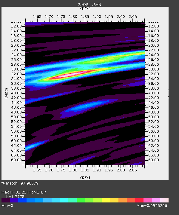
| Estimated Moho Depth: |
32.25 km |
| Estimated Crust Vp/Vs: |
1.78 |
| Assumed Crust Vp: |
6.459 km/s |
| Estimated Crust Vs: |
3.634 km/s |
| Estimated Crust Poisson's Ratio: |
0.27 |
|
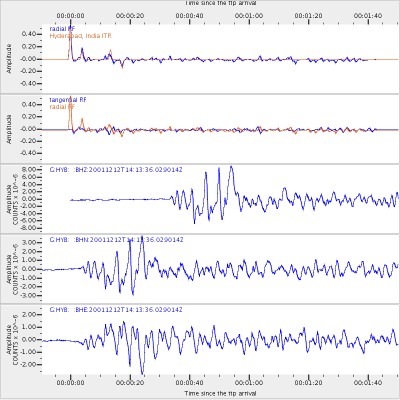
| Radial Match: |
97.98579 % |
| Radial Bump: |
241 |
| Transverse Match: |
92.12942 % |
| Transverse Bump: |
400 |
| SOD ConfigId: |
20082 |
| Insert Time: |
2010-02-26 22:39:32.278 +0000 |
| GWidth: |
2.5 |
| Max Bumps: |
400 |
| Tol: |
0.001 |
|
Signal To Noise
| Channel | StoN | STA | LTA |
| G:HYB: :BHN:20011212T14:13:36.029014Z | 4.391383 | 1.955504E-7 | 4.453048E-8 |
| G:HYB: :BHE:20011212T14:13:36.029014Z | 2.3028536 | 1.3881795E-7 | 6.028084E-8 |
| G:HYB: :BHZ:20011212T14:13:36.029014Z | 5.043507 | 3.9700296E-7 | 7.871565E-8 |
| Arrivals |
| Ps | 4.0 SECOND |
| PpPs | 13 SECOND |
| PsPs/PpSs | 17 SECOND |


