You are here: Home > Network List > UW - Pacific Northwest Regional Seismic Network Stations List
> Station TUCA Wood Farm, Starbuck, WA, USA > Earthquake Result Viewer
TUCA Wood Farm, Starbuck, WA, USA - Earthquake Result Viewer
| Earthquake location: |
Turkey |
| Earthquake latitude/longitude: |
38.7/43.5 |
| Earthquake time(UTC): |
2011/10/23 (296) 10:41:22 GMT |
| Earthquake Depth: |
16 km |
| Earthquake Magnitude: |
6.9 MB, 7.3 MS, 7.3 MW, 7.1 MW |
| Earthquake Catalog/Contributor: |
WHDF/NEIC |
|
| Network: |
UW Pacific Northwest Regional Seismic Network |
| Station: |
TUCA Wood Farm, Starbuck, WA, USA |
| Lat/Lon: |
46.51 N/118.15 W |
| Elevation: |
304 m |
|
| Distance: |
93.6 deg |
| Az: |
347.424 deg |
| Baz: |
14.278 deg |
| Ray Param: |
0.04123259 |
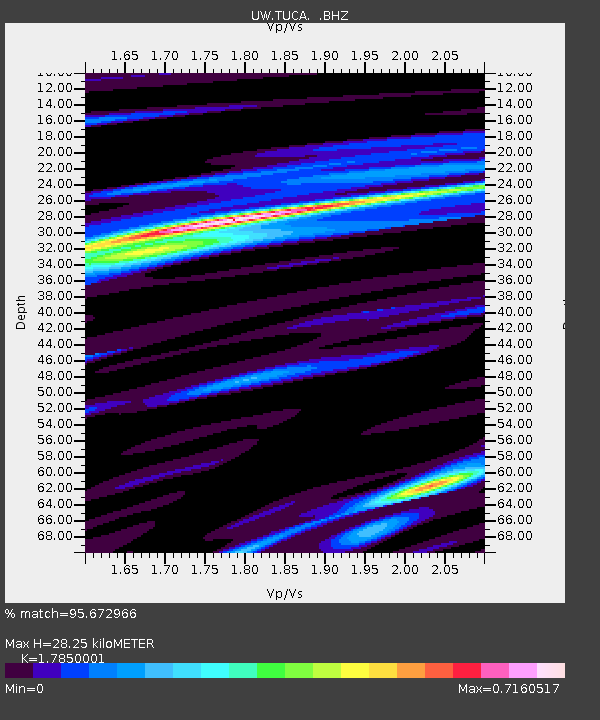
| Estimated Moho Depth: |
28.25 km |
| Estimated Crust Vp/Vs: |
1.79 |
| Assumed Crust Vp: |
6.419 km/s |
| Estimated Crust Vs: |
3.596 km/s |
| Estimated Crust Poisson's Ratio: |
0.27 |
|
| Radial Match: |
95.672966 % |
| Radial Bump: |
383 |
| Transverse Match: |
89.993935 % |
| Transverse Bump: |
400 |
| SOD ConfigId: |
424168 |
| Insert Time: |
2012-02-16 06:26:36.262 +0000 |
| GWidth: |
2.5 |
| Max Bumps: |
400 |
| Tol: |
0.001 |
|
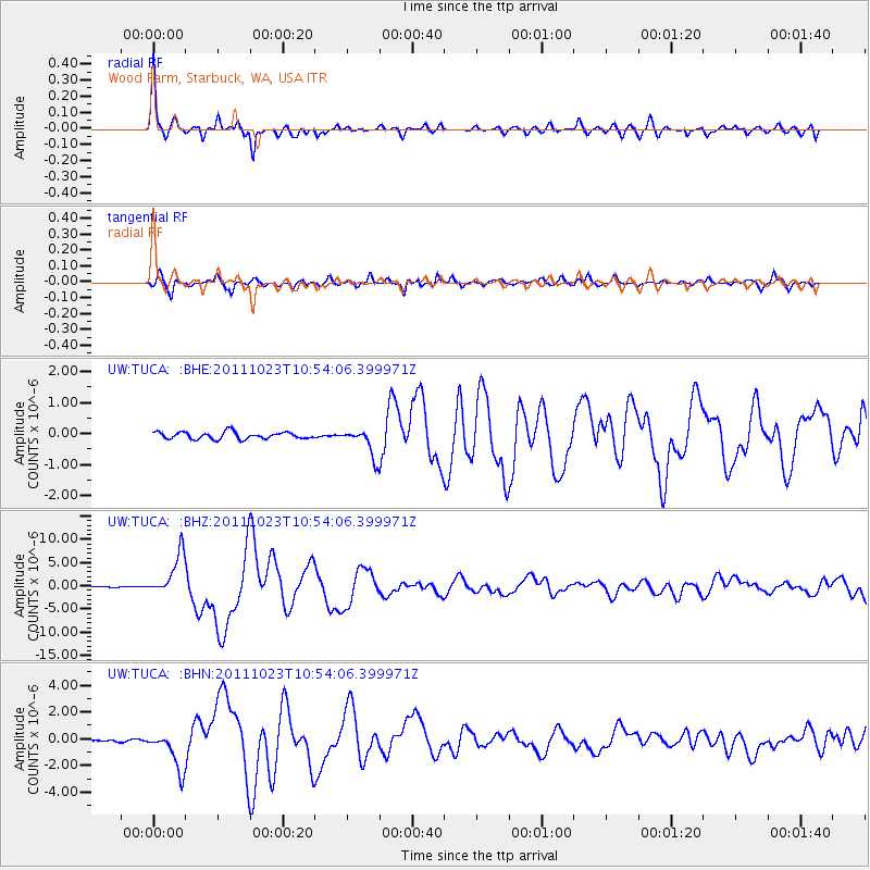
Signal To Noise
| Channel | StoN | STA | LTA |
| UW:TUCA: :BHZ:20111023T10:54:06.399971Z | 47.00753 | 4.510983E-6 | 9.5962996E-8 |
| UW:TUCA: :BHN:20111023T10:54:06.399971Z | 18.301493 | 1.4388231E-6 | 7.86178E-8 |
| UW:TUCA: :BHE:20111023T10:54:06.399971Z | 4.10102 | 4.6104216E-7 | 1.1242135E-7 |
| Arrivals |
| Ps | 3.5 SECOND |
| PpPs | 12 SECOND |
| PsPs/PpSs | 16 SECOND |


