You are here: Home > Network List > G - GEOSCOPE Stations List
> Station HYB Hyderabad, India > Earthquake Result Viewer
HYB Hyderabad, India - Earthquake Result Viewer
| Earthquake location: |
Banda Sea |
| Earthquake latitude/longitude: |
-6.9/128.9 |
| Earthquake time(UTC): |
2001/11/20 (324) 21:08:18 GMT |
| Earthquake Depth: |
33 km |
| Earthquake Magnitude: |
5.7 MB, 6.0 MS, 6.3 MW, 6.2 MW |
| Earthquake Catalog/Contributor: |
WHDF/NEIC |
|
| Network: |
G GEOSCOPE |
| Station: |
HYB Hyderabad, India |
| Lat/Lon: |
17.42 N/78.55 E |
| Elevation: |
510 m |
|
| Distance: |
55.3 deg |
| Az: |
296.578 deg |
| Baz: |
111.552 deg |
| Ray Param: |
0.06482189 |
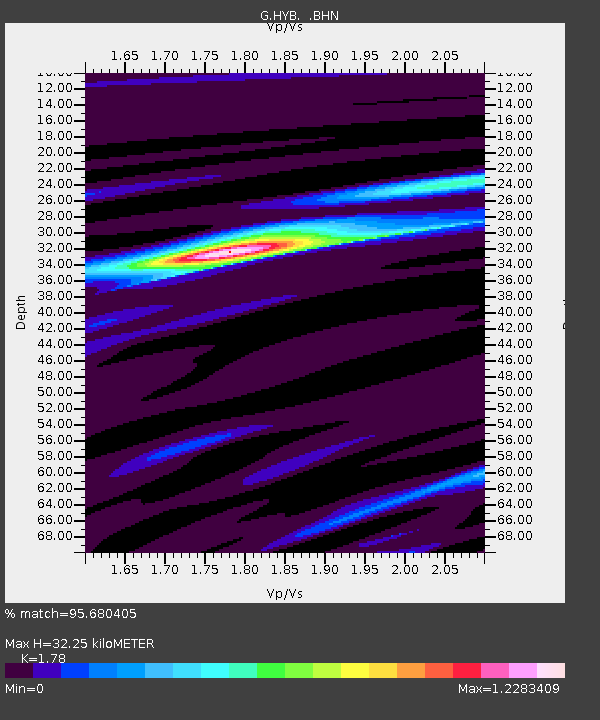
| Estimated Moho Depth: |
32.25 km |
| Estimated Crust Vp/Vs: |
1.78 |
| Assumed Crust Vp: |
6.459 km/s |
| Estimated Crust Vs: |
3.629 km/s |
| Estimated Crust Poisson's Ratio: |
0.27 |
|
| Radial Match: |
95.680405 % |
| Radial Bump: |
270 |
| Transverse Match: |
78.24913 % |
| Transverse Bump: |
400 |
| SOD ConfigId: |
20082 |
| Insert Time: |
2010-02-26 22:39:37.745 +0000 |
| GWidth: |
2.5 |
| Max Bumps: |
400 |
| Tol: |
0.001 |
|
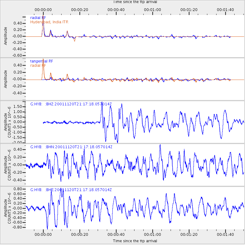
Signal To Noise
| Channel | StoN | STA | LTA |
| G:HYB: :BHN:20011120T21:17:18.057014Z | 3.2645643 | 1.4024741E-7 | 4.296053E-8 |
| G:HYB: :BHE:20011120T21:17:18.057014Z | 8.593752 | 3.6771334E-7 | 4.278845E-8 |
| G:HYB: :BHZ:20011120T21:17:18.057014Z | 15.82592 | 8.665988E-7 | 5.4758193E-8 |
| Arrivals |
| Ps | 4.1 SECOND |
| PpPs | 13 SECOND |
| PsPs/PpSs | 17 SECOND |


