You are here: Home > Network List > TA - USArray Transportable Network (new EarthScope stations) Stations List
> Station N59A State Game Land 141, Hazleton, PA, USA > Earthquake Result Viewer
N59A State Game Land 141, Hazleton, PA, USA - Earthquake Result Viewer
*The percent match for this event was below the threshold and hence no stack was calculated.
| Earthquake location: |
Turkey |
| Earthquake latitude/longitude: |
38.8/43.4 |
| Earthquake time(UTC): |
2011/10/23 (296) 10:56:49 GMT |
| Earthquake Depth: |
5.0 km |
| Earthquake Magnitude: |
5.6 MB, 5.5 ML |
| Earthquake Catalog/Contributor: |
WHDF/NEIC |
|
| Network: |
TA USArray Transportable Network (new EarthScope stations) |
| Station: |
N59A State Game Land 141, Hazleton, PA, USA |
| Lat/Lon: |
40.92 N/75.77 W |
| Elevation: |
508 m |
|
| Distance: |
83.2 deg |
| Az: |
318.233 deg |
| Baz: |
43.367 deg |
| Ray Param: |
$rayparam |
*The percent match for this event was below the threshold and hence was not used in the summary stack. |
|
| Radial Match: |
81.87635 % |
| Radial Bump: |
263 |
| Transverse Match: |
50.52 % |
| Transverse Bump: |
369 |
| SOD ConfigId: |
424168 |
| Insert Time: |
2012-02-16 06:59:22.132 +0000 |
| GWidth: |
2.5 |
| Max Bumps: |
400 |
| Tol: |
0.001 |
|
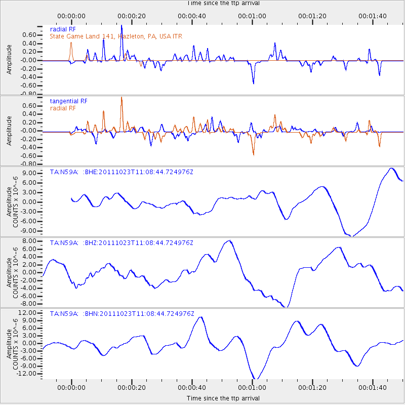
Signal To Noise
| Channel | StoN | STA | LTA |
| TA:N59A: :BHZ:20111023T11:08:44.724976Z | 2.08909 | 3.1356676E-6 | 1.5009729E-6 |
| TA:N59A: :BHN:20111023T11:08:44.724976Z | 0.8864344 | 1.5216797E-6 | 1.7166299E-6 |
| TA:N59A: :BHE:20111023T11:08:44.724976Z | 1.1417818 | 1.5817672E-6 | 1.3853498E-6 |
| Arrivals |
| Ps | |
| PpPs | |
| PsPs/PpSs | |


