You are here: Home > Network List > XJ13 - CRAFTI Stations List
> Station LL23 Sali PS > Earthquake Result Viewer
LL23 Sali PS - Earthquake Result Viewer
| Earthquake location: |
Bouvet Island Region |
| Earthquake latitude/longitude: |
-53.5/8.7 |
| Earthquake time(UTC): |
2014/04/15 (105) 03:57:02 GMT |
| Earthquake Depth: |
12 km |
| Earthquake Magnitude: |
6.9 MWP, 6.8 MI, 6.9 MI |
| Earthquake Catalog/Contributor: |
NEIC PDE/NEIC COMCAT |
|
| Network: |
XJ CRAFTI |
| Station: |
LL23 Sali PS |
| Lat/Lon: |
2.30 S/35.69 E |
| Elevation: |
1257 m |
|
| Distance: |
55.7 deg |
| Az: |
33.289 deg |
| Baz: |
199.144 deg |
| Ray Param: |
0.064618886 |
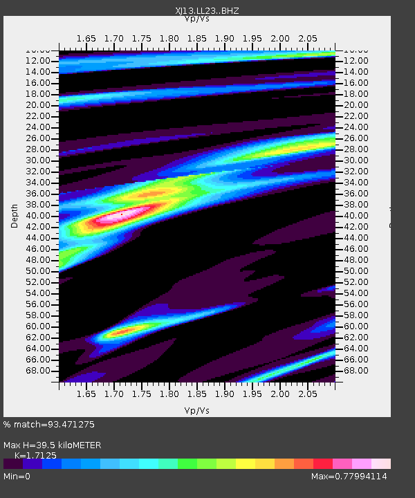
| Estimated Moho Depth: |
39.5 km |
| Estimated Crust Vp/Vs: |
1.71 |
| Assumed Crust Vp: |
6.576 km/s |
| Estimated Crust Vs: |
3.84 km/s |
| Estimated Crust Poisson's Ratio: |
0.24 |
|
| Radial Match: |
93.471275 % |
| Radial Bump: |
238 |
| Transverse Match: |
74.9186 % |
| Transverse Bump: |
400 |
| SOD ConfigId: |
3390531 |
| Insert Time: |
2019-04-11 10:04:03.277 +0000 |
| GWidth: |
2.5 |
| Max Bumps: |
400 |
| Tol: |
0.001 |
|

Signal To Noise
| Channel | StoN | STA | LTA |
| XJ:LL23: :BHZ:20140415T04:06:07.720007Z | 21.293896 | 1.3064198E-6 | 6.135184E-8 |
| XJ:LL23: :BHN:20140415T04:06:07.720007Z | 9.620833 | 6.437153E-7 | 6.690847E-8 |
| XJ:LL23: :BHE:20140415T04:06:07.720007Z | 4.330868 | 3.0642988E-7 | 7.0754844E-8 |
| Arrivals |
| Ps | 4.5 SECOND |
| PpPs | 15 SECOND |
| PsPs/PpSs | 20 SECOND |


