You are here: Home > Network List > XJ13 - CRAFTI Stations List
> Station LL22 Malambo SS > Earthquake Result Viewer
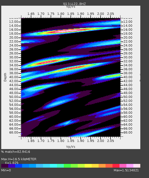
LL22 Malambo SS - Earthquake Result Viewer
| Earthquake location: |
Bouvet Island Region |
| Earthquake latitude/longitude: |
-53.5/8.7 |
| Earthquake time(UTC): |
2014/04/15 (105) 03:57:02 GMT |
| Earthquake Depth: |
12 km |
| Earthquake Magnitude: |
6.9 MWP, 6.8 MI, 6.9 MI |
| Earthquake Catalog/Contributor: |
NEIC PDE/NEIC COMCAT |
|
| Network: |
XJ CRAFTI |
| Station: |
LL22 Malambo SS |
| Lat/Lon: |
2.52 S/35.60 E |
| Elevation: |
1222 m |
|
| Distance: |
55.5 deg |
| Az: |
33.273 deg |
| Baz: |
199.139 deg |
| Ray Param: |
0.06477434 |
| Estimated Moho Depth: |
16.5 km |
| Estimated Crust Vp/Vs: |
1.83 |
| Assumed Crust Vp: |
6.576 km/s |
| Estimated Crust Vs: |
3.603 km/s |
| Estimated Crust Poisson's Ratio: |
0.29 |
|
| Radial Match: |
82.9416 % |
| Radial Bump: |
400 |
| Transverse Match: |
63.93432 % |
| Transverse Bump: |
400 |
| SOD ConfigId: |
3390531 |
| Insert Time: |
2019-04-11 10:04:03.784 +0000 |
| GWidth: |
2.5 |
| Max Bumps: |
400 |
| Tol: |
0.001 |
|

Signal To Noise
| Channel | StoN | STA | LTA |
| XJ:LL22: :BHZ:20140415T04:06:06.019995Z | 14.522185 | 1.5833441E-6 | 1.0902933E-7 |
| XJ:LL22: :BHN:20140415T04:06:06.019995Z | 7.5498037 | 8.2489856E-7 | 1.09260924E-7 |
| XJ:LL22: :BHE:20140415T04:06:06.019995Z | 2.3315961 | 2.6218285E-7 | 1.124478E-7 |
| Arrivals |
| Ps | 2.2 SECOND |
| PpPs | 6.7 SECOND |
| PsPs/PpSs | 8.9 SECOND |


