You are here: Home > Network List > TA - USArray Transportable Network (new EarthScope stations) Stations List
> Station Z47A Carrollton, AL, USA > Earthquake Result Viewer
Z47A Carrollton, AL, USA - Earthquake Result Viewer

| Earthquake location: |
Turkey |
| Earthquake latitude/longitude: |
38.8/43.3 |
| Earthquake time(UTC): |
2011/10/23 (296) 11:32:41 GMT |
| Earthquake Depth: |
5.0 km |
| Earthquake Magnitude: |
5.7 MB, 5.5 ML |
| Earthquake Catalog/Contributor: |
WHDF/NEIC |
|
| Network: |
TA USArray Transportable Network (new EarthScope stations) |
| Station: |
Z47A Carrollton, AL, USA |
| Lat/Lon: |
33.20 N/88.07 W |
| Elevation: |
65 m |
|
| Distance: |
95.3 deg |
| Az: |
320.806 deg |
| Baz: |
36.077 deg |
| Ray Param: |
0.040815465 |
| Estimated Moho Depth: |
10.0 km |
| Estimated Crust Vp/Vs: |
1.61 |
| Assumed Crust Vp: |
6.201 km/s |
| Estimated Crust Vs: |
3.846 km/s |
| Estimated Crust Poisson's Ratio: |
0.19 |
|
| Radial Match: |
95.525635 % |
| Radial Bump: |
343 |
| Transverse Match: |
57.010433 % |
| Transverse Bump: |
320 |
| SOD ConfigId: |
424168 |
| Insert Time: |
2012-02-16 07:21:44.032 +0000 |
| GWidth: |
2.5 |
| Max Bumps: |
400 |
| Tol: |
0.001 |
|
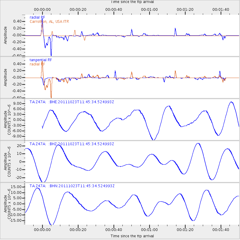
Signal To Noise
| Channel | StoN | STA | LTA |
| TA:Z47A: :BHZ:20111023T11:45:34.524993Z | 2.296471 | 2.309947E-5 | 1.0058681E-5 |
| TA:Z47A: :BHN:20111023T11:45:34.524993Z | 2.0124743 | 1.0367528E-5 | 5.151633E-6 |
| TA:Z47A: :BHE:20111023T11:45:34.524993Z | 1.256532 | 4.8310126E-6 | 3.8447197E-6 |
| Arrivals |
| Ps | 1.0 SECOND |
| PpPs | 4.1 SECOND |
| PsPs/PpSs | 5.1 SECOND |


