You are here: Home > Network List > TA - USArray Transportable Network (new EarthScope stations) Stations List
> Station K40A Colesburg, IA, USA > Earthquake Result Viewer
K40A Colesburg, IA, USA - Earthquake Result Viewer
| Earthquake location: |
Turkey |
| Earthquake latitude/longitude: |
38.8/43.3 |
| Earthquake time(UTC): |
2011/10/23 (296) 11:32:41 GMT |
| Earthquake Depth: |
5.0 km |
| Earthquake Magnitude: |
5.7 MB, 5.5 ML |
| Earthquake Catalog/Contributor: |
WHDF/NEIC |
|
| Network: |
TA USArray Transportable Network (new EarthScope stations) |
| Station: |
K40A Colesburg, IA, USA |
| Lat/Lon: |
42.70 N/91.14 W |
| Elevation: |
274 m |
|
| Distance: |
88.9 deg |
| Az: |
328.235 deg |
| Baz: |
33.913 deg |
| Ray Param: |
0.04222147 |
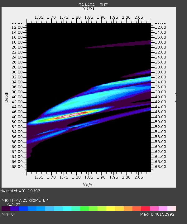
| Estimated Moho Depth: |
47.25 km |
| Estimated Crust Vp/Vs: |
1.77 |
| Assumed Crust Vp: |
6.53 km/s |
| Estimated Crust Vs: |
3.69 km/s |
| Estimated Crust Poisson's Ratio: |
0.27 |
|
| Radial Match: |
81.19697 % |
| Radial Bump: |
400 |
| Transverse Match: |
46.310326 % |
| Transverse Bump: |
298 |
| SOD ConfigId: |
424168 |
| Insert Time: |
2012-02-16 07:22:25.311 +0000 |
| GWidth: |
2.5 |
| Max Bumps: |
400 |
| Tol: |
0.001 |
|
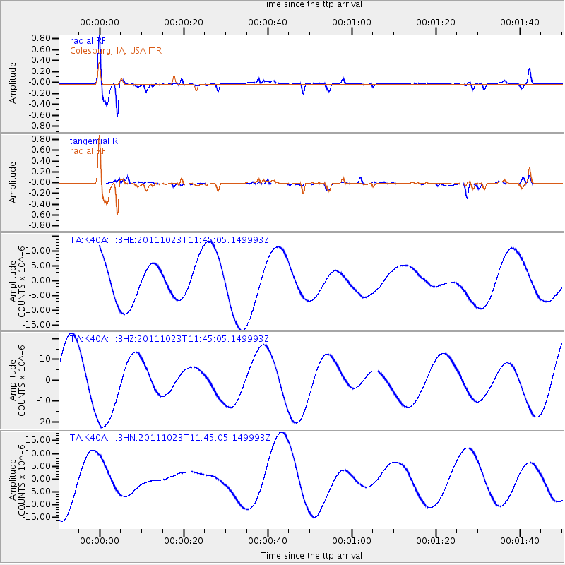
Signal To Noise
| Channel | StoN | STA | LTA |
| TA:K40A: :BHZ:20111023T11:45:05.149993Z | 1.4178998 | 1.8240697E-5 | 1.2864588E-5 |
| TA:K40A: :BHN:20111023T11:45:05.149993Z | 0.7735302 | 7.492969E-6 | 9.686718E-6 |
| TA:K40A: :BHE:20111023T11:45:05.149993Z | 1.7644535 | 1.1359959E-5 | 6.4382307E-6 |
| Arrivals |
| Ps | 5.7 SECOND |
| PpPs | 20 SECOND |
| PsPs/PpSs | 25 SECOND |


