You are here: Home > Network List > TA - USArray Transportable Network (new EarthScope stations) Stations List
> Station G43A Wallace, MI, USA > Earthquake Result Viewer
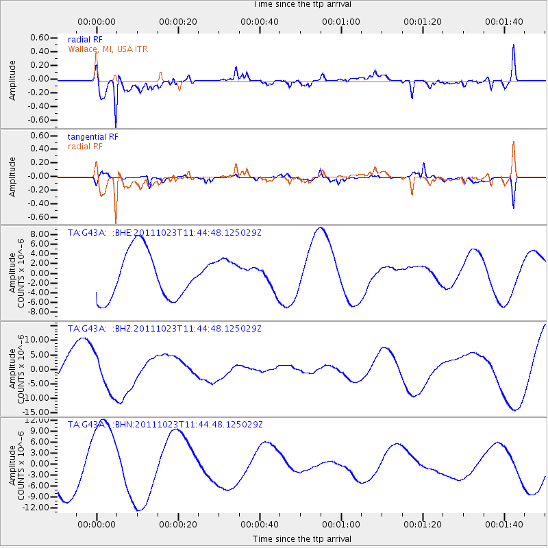
G43A Wallace, MI, USA - Earthquake Result Viewer
*The percent match for this event was below the threshold and hence no stack was calculated.
| Earthquake location: |
Turkey |
| Earthquake latitude/longitude: |
38.8/43.3 |
| Earthquake time(UTC): |
2011/10/23 (296) 11:32:41 GMT |
| Earthquake Depth: |
5.0 km |
| Earthquake Magnitude: |
5.7 MB, 5.5 ML |
| Earthquake Catalog/Contributor: |
WHDF/NEIC |
|
| Network: |
TA USArray Transportable Network (new EarthScope stations) |
| Station: |
G43A Wallace, MI, USA |
| Lat/Lon: |
45.26 N/87.69 W |
| Elevation: |
213 m |
|
| Distance: |
85.4 deg |
| Az: |
327.664 deg |
| Baz: |
36.275 deg |
| Ray Param: |
$rayparam |
*The percent match for this event was below the threshold and hence was not used in the summary stack. |
|
| Radial Match: |
77.28657 % |
| Radial Bump: |
400 |
| Transverse Match: |
34.55095 % |
| Transverse Bump: |
329 |
| SOD ConfigId: |
424168 |
| Insert Time: |
2012-02-16 07:23:34.898 +0000 |
| GWidth: |
2.5 |
| Max Bumps: |
400 |
| Tol: |
0.001 |
|
Signal To Noise
| Channel | StoN | STA | LTA |
| TA:G43A: :BHZ:20111023T11:44:48.125029Z | 1.5892003 | 6.6404496E-6 | 4.178485E-6 |
| TA:G43A: :BHN:20111023T11:44:48.125029Z | 2.106011 | 1.1425028E-5 | 5.4249613E-6 |
| TA:G43A: :BHE:20111023T11:44:48.125029Z | 0.7000995 | 3.4150166E-6 | 4.8779016E-6 |
| Arrivals |
| Ps | |
| PpPs | |
| PsPs/PpSs | |


