You are here: Home > Network List > XJ13 - CRAFTI Stations List
> Station LN16 Kitarini PS > Earthquake Result Viewer
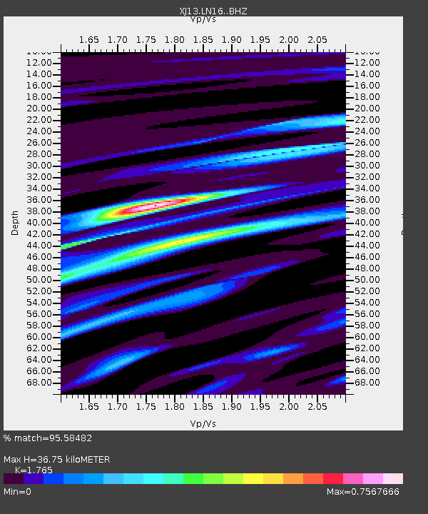
LN16 Kitarini PS - Earthquake Result Viewer
| Earthquake location: |
Bouvet Island Region |
| Earthquake latitude/longitude: |
-53.5/8.7 |
| Earthquake time(UTC): |
2014/04/15 (105) 03:57:02 GMT |
| Earthquake Depth: |
12 km |
| Earthquake Magnitude: |
6.9 MWP, 6.8 MI, 6.9 MI |
| Earthquake Catalog/Contributor: |
NEIC PDE/NEIC COMCAT |
|
| Network: |
XJ CRAFTI |
| Station: |
LN16 Kitarini PS |
| Lat/Lon: |
2.62 S/36.46 E |
| Elevation: |
1717 m |
|
| Distance: |
55.7 deg |
| Az: |
34.302 deg |
| Baz: |
199.682 deg |
| Ray Param: |
0.064648874 |
| Estimated Moho Depth: |
36.75 km |
| Estimated Crust Vp/Vs: |
1.76 |
| Assumed Crust Vp: |
6.601 km/s |
| Estimated Crust Vs: |
3.74 km/s |
| Estimated Crust Poisson's Ratio: |
0.26 |
|
| Radial Match: |
95.58482 % |
| Radial Bump: |
281 |
| Transverse Match: |
81.61525 % |
| Transverse Bump: |
400 |
| SOD ConfigId: |
3390531 |
| Insert Time: |
2019-04-11 10:04:07.305 +0000 |
| GWidth: |
2.5 |
| Max Bumps: |
400 |
| Tol: |
0.001 |
|

Signal To Noise
| Channel | StoN | STA | LTA |
| XJ:LN16: :BHZ:20140415T04:06:07.400Z | 13.946888 | 1.126085E-6 | 8.0740946E-8 |
| XJ:LN16: :BHN:20140415T04:06:07.400Z | 3.7173097 | 5.825222E-7 | 1.5670533E-7 |
| XJ:LN16: :BHE:20140415T04:06:07.400Z | 2.5167778 | 2.1389266E-7 | 8.498671E-8 |
| Arrivals |
| Ps | 4.5 SECOND |
| PpPs | 15 SECOND |
| PsPs/PpSs | 19 SECOND |


