You are here: Home > Network List > XJ13 - CRAFTI Stations List
> Station MW42 Engaruka NEW > Earthquake Result Viewer
MW42 Engaruka NEW - Earthquake Result Viewer
| Earthquake location: |
Bouvet Island Region |
| Earthquake latitude/longitude: |
-53.5/8.7 |
| Earthquake time(UTC): |
2014/04/15 (105) 03:57:02 GMT |
| Earthquake Depth: |
12 km |
| Earthquake Magnitude: |
6.9 MWP, 6.8 MI, 6.9 MI |
| Earthquake Catalog/Contributor: |
NEIC PDE/NEIC COMCAT |
|
| Network: |
XJ CRAFTI |
| Station: |
MW42 Engaruka NEW |
| Lat/Lon: |
3.04 S/36.10 E |
| Elevation: |
753 m |
|
| Distance: |
55.1 deg |
| Az: |
34.057 deg |
| Baz: |
199.561 deg |
| Ray Param: |
0.06498689 |
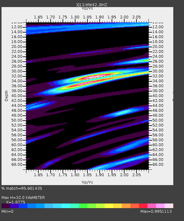
| Estimated Moho Depth: |
32.0 km |
| Estimated Crust Vp/Vs: |
1.88 |
| Assumed Crust Vp: |
6.601 km/s |
| Estimated Crust Vs: |
3.516 km/s |
| Estimated Crust Poisson's Ratio: |
0.30 |
|
| Radial Match: |
95.681435 % |
| Radial Bump: |
233 |
| Transverse Match: |
82.91743 % |
| Transverse Bump: |
400 |
| SOD ConfigId: |
3390531 |
| Insert Time: |
2019-04-11 10:04:13.442 +0000 |
| GWidth: |
2.5 |
| Max Bumps: |
400 |
| Tol: |
0.001 |
|

Signal To Noise
| Channel | StoN | STA | LTA |
| XJ:MW42: :BHZ:20140415T04:06:03.699988Z | 22.248247 | 1.8872287E-6 | 8.482595E-8 |
| XJ:MW42: :BHN:20140415T04:06:03.699988Z | 3.6396506 | 6.1083904E-7 | 1.6782903E-7 |
| XJ:MW42: :BHE:20140415T04:06:03.699988Z | 1.6202526 | 3.1606504E-7 | 1.9507145E-7 |
| Arrivals |
| Ps | 4.5 SECOND |
| PpPs | 13 SECOND |
| PsPs/PpSs | 18 SECOND |


