You are here: Home > Network List > XJ13 - CRAFTI Stations List
> Station PR61 Kiloki Boma > Earthquake Result Viewer
PR61 Kiloki Boma - Earthquake Result Viewer
| Earthquake location: |
Bouvet Island Region |
| Earthquake latitude/longitude: |
-53.5/8.7 |
| Earthquake time(UTC): |
2014/04/15 (105) 03:57:02 GMT |
| Earthquake Depth: |
12 km |
| Earthquake Magnitude: |
6.9 MWP, 6.8 MI, 6.9 MI |
| Earthquake Catalog/Contributor: |
NEIC PDE/NEIC COMCAT |
|
| Network: |
XJ CRAFTI |
| Station: |
PR61 Kiloki Boma |
| Lat/Lon: |
2.96 S/35.25 E |
| Elevation: |
1549 m |
|
| Distance: |
54.9 deg |
| Az: |
33.043 deg |
| Baz: |
199.024 deg |
| Ray Param: |
0.065124065 |
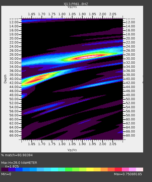
| Estimated Moho Depth: |
29.0 km |
| Estimated Crust Vp/Vs: |
1.92 |
| Assumed Crust Vp: |
6.576 km/s |
| Estimated Crust Vs: |
3.416 km/s |
| Estimated Crust Poisson's Ratio: |
0.32 |
|
| Radial Match: |
90.98394 % |
| Radial Bump: |
260 |
| Transverse Match: |
67.9307 % |
| Transverse Bump: |
400 |
| SOD ConfigId: |
3390531 |
| Insert Time: |
2019-04-11 10:04:18.619 +0000 |
| GWidth: |
2.5 |
| Max Bumps: |
400 |
| Tol: |
0.001 |
|

Signal To Noise
| Channel | StoN | STA | LTA |
| XJ:PR61: :BHZ:20140415T04:06:02.220007Z | 21.23556 | 1.6386398E-6 | 7.7164906E-8 |
| XJ:PR61: :BHN:20140415T04:06:02.220007Z | 9.191831 | 8.9015606E-7 | 9.6842086E-8 |
| XJ:PR61: :BHE:20140415T04:06:02.220007Z | 2.9051056 | 3.923238E-7 | 1.3504632E-7 |
| Arrivals |
| Ps | 4.3 SECOND |
| PpPs | 12 SECOND |
| PsPs/PpSs | 17 SECOND |


