You are here: Home > Network List > XJ13 - CRAFTI Stations List
> Station PR63 Meshili Boma > Earthquake Result Viewer
PR63 Meshili Boma - Earthquake Result Viewer
| Earthquake location: |
Bouvet Island Region |
| Earthquake latitude/longitude: |
-53.5/8.7 |
| Earthquake time(UTC): |
2014/04/15 (105) 03:57:02 GMT |
| Earthquake Depth: |
12 km |
| Earthquake Magnitude: |
6.9 MWP, 6.8 MI, 6.9 MI |
| Earthquake Catalog/Contributor: |
NEIC PDE/NEIC COMCAT |
|
| Network: |
XJ CRAFTI |
| Station: |
PR63 Meshili Boma |
| Lat/Lon: |
2.99 S/35.51 E |
| Elevation: |
1362 m |
|
| Distance: |
55.0 deg |
| Az: |
33.355 deg |
| Baz: |
199.19 deg |
| Ray Param: |
0.06508926 |
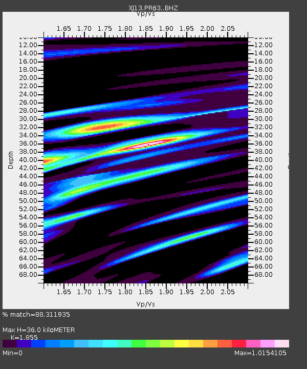
| Estimated Moho Depth: |
36.0 km |
| Estimated Crust Vp/Vs: |
1.86 |
| Assumed Crust Vp: |
6.576 km/s |
| Estimated Crust Vs: |
3.545 km/s |
| Estimated Crust Poisson's Ratio: |
0.30 |
|
| Radial Match: |
88.311935 % |
| Radial Bump: |
360 |
| Transverse Match: |
67.51543 % |
| Transverse Bump: |
400 |
| SOD ConfigId: |
3390531 |
| Insert Time: |
2019-04-11 10:04:20.499 +0000 |
| GWidth: |
2.5 |
| Max Bumps: |
400 |
| Tol: |
0.001 |
|

Signal To Noise
| Channel | StoN | STA | LTA |
| XJ:PR63: :BHZ:20140415T04:06:02.600012Z | 20.377626 | 1.8755849E-6 | 9.204138E-8 |
| XJ:PR63: :BHN:20140415T04:06:02.600012Z | 6.172291 | 8.8138745E-7 | 1.4279746E-7 |
| XJ:PR63: :BHE:20140415T04:06:02.600012Z | 2.6087792 | 3.8379878E-7 | 1.4711816E-7 |
| Arrivals |
| Ps | 4.9 SECOND |
| PpPs | 15 SECOND |
| PsPs/PpSs | 20 SECOND |


