You are here: Home > Network List > TA - USArray Transportable Network (new EarthScope stations) Stations List
> Station N54A Moraine State Park, Portersville, PA, USA > Earthquake Result Viewer
N54A Moraine State Park, Portersville, PA, USA - Earthquake Result Viewer
| Earthquake location: |
Turkey |
| Earthquake latitude/longitude: |
38.6/43.1 |
| Earthquake time(UTC): |
2011/10/23 (296) 20:45:34 GMT |
| Earthquake Depth: |
5.0 km |
| Earthquake Magnitude: |
6.0 MB, 5.6 MS, 6.0 MW, 5.9 MW |
| Earthquake Catalog/Contributor: |
WHDF/NEIC |
|
| Network: |
TA USArray Transportable Network (new EarthScope stations) |
| Station: |
N54A Moraine State Park, Portersville, PA, USA |
| Lat/Lon: |
40.96 N/79.99 W |
| Elevation: |
408 m |
|
| Distance: |
85.3 deg |
| Az: |
320.444 deg |
| Baz: |
41.192 deg |
| Ray Param: |
0.04489269 |
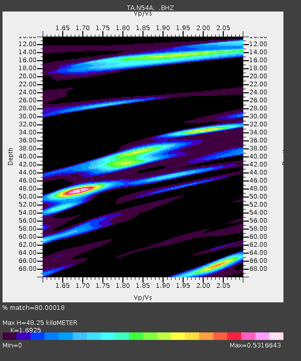
| Estimated Moho Depth: |
48.25 km |
| Estimated Crust Vp/Vs: |
1.69 |
| Assumed Crust Vp: |
6.121 km/s |
| Estimated Crust Vs: |
3.616 km/s |
| Estimated Crust Poisson's Ratio: |
0.23 |
|
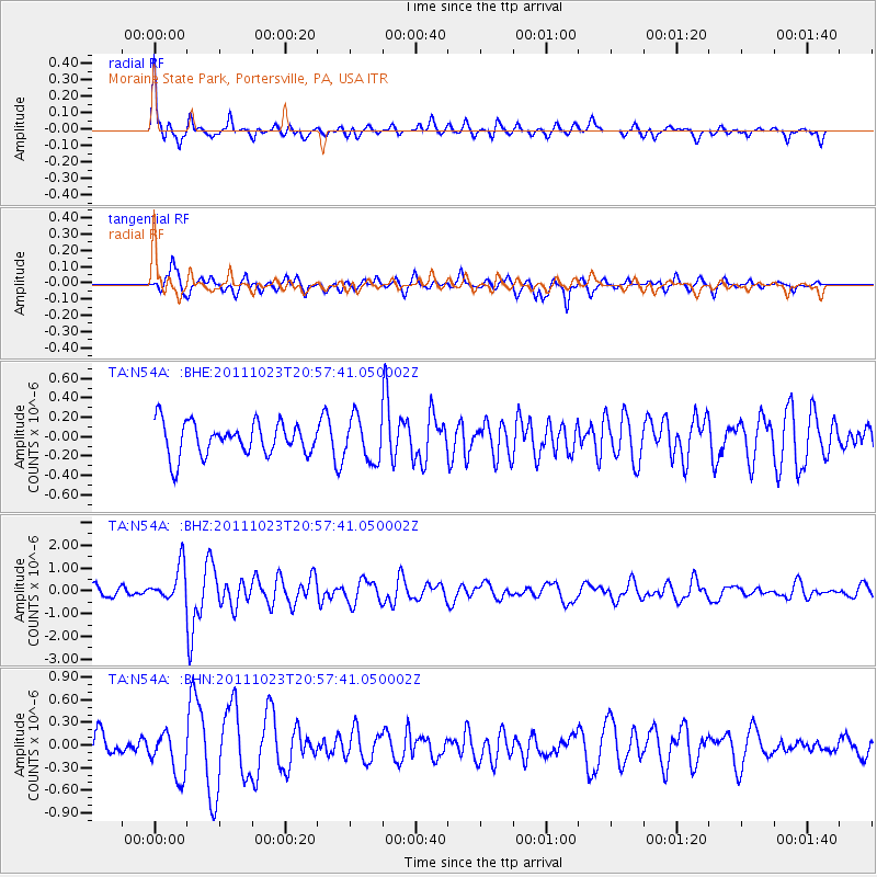
| Radial Match: |
80.00018 % |
| Radial Bump: |
400 |
| Transverse Match: |
66.90281 % |
| Transverse Bump: |
381 |
| SOD ConfigId: |
424168 |
| Insert Time: |
2012-02-16 07:53:45.582 +0000 |
| GWidth: |
2.5 |
| Max Bumps: |
400 |
| Tol: |
0.001 |
|
Signal To Noise
| Channel | StoN | STA | LTA |
| TA:N54A: :BHZ:20111023T20:57:41.050002Z | 3.6382246 | 7.825549E-7 | 2.1509251E-7 |
| TA:N54A: :BHN:20111023T20:57:41.050002Z | 2.09275 | 2.9968098E-7 | 1.431996E-7 |
| TA:N54A: :BHE:20111023T20:57:41.050002Z | 1.3334818 | 2.2264388E-7 | 1.6696431E-7 |
| Arrivals |
| Ps | 5.6 SECOND |
| PpPs | 21 SECOND |
| PsPs/PpSs | 26 SECOND |


