You are here: Home > Network List > TA - USArray Transportable Network (new EarthScope stations) Stations List
> Station R42A Luebbering, MO, USA > Earthquake Result Viewer
R42A Luebbering, MO, USA - Earthquake Result Viewer
*The percent match for this event was below the threshold and hence no stack was calculated.
| Earthquake location: |
Turkey |
| Earthquake latitude/longitude: |
38.6/43.1 |
| Earthquake time(UTC): |
2011/10/23 (296) 20:45:34 GMT |
| Earthquake Depth: |
5.0 km |
| Earthquake Magnitude: |
6.0 MB, 5.6 MS, 6.0 MW, 5.9 MW |
| Earthquake Catalog/Contributor: |
WHDF/NEIC |
|
| Network: |
TA USArray Transportable Network (new EarthScope stations) |
| Station: |
R42A Luebbering, MO, USA |
| Lat/Lon: |
38.28 N/90.79 W |
| Elevation: |
218 m |
|
| Distance: |
92.5 deg |
| Az: |
325.397 deg |
| Baz: |
34.412 deg |
| Ray Param: |
$rayparam |
*The percent match for this event was below the threshold and hence was not used in the summary stack. |
|
| Radial Match: |
63.458565 % |
| Radial Bump: |
400 |
| Transverse Match: |
51.79542 % |
| Transverse Bump: |
400 |
| SOD ConfigId: |
424168 |
| Insert Time: |
2012-02-16 08:01:47.713 +0000 |
| GWidth: |
2.5 |
| Max Bumps: |
400 |
| Tol: |
0.001 |
|
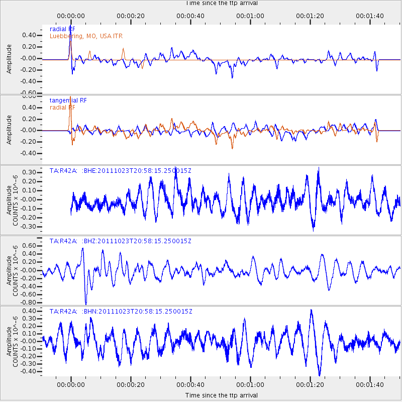
Signal To Noise
| Channel | StoN | STA | LTA |
| TA:R42A: :BHZ:20111023T20:58:15.250015Z | 1.9554594 | 2.6364313E-7 | 1.3482413E-7 |
| TA:R42A: :BHN:20111023T20:58:15.250015Z | 1.1294209 | 1.2891708E-7 | 1.1414442E-7 |
| TA:R42A: :BHE:20111023T20:58:15.250015Z | 2.1030753 | 1.3460277E-7 | 6.400283E-8 |
| Arrivals |
| Ps | |
| PpPs | |
| PsPs/PpSs | |


