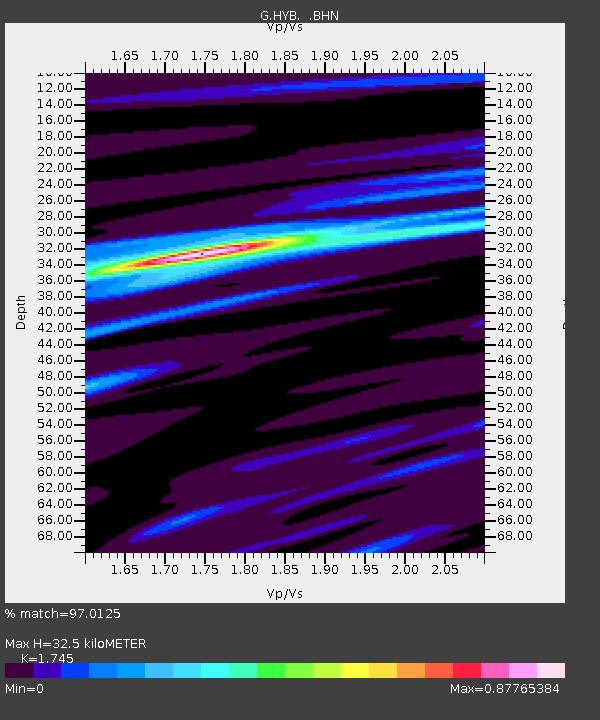
HYB Hyderabad, India - Earthquake Result Viewer
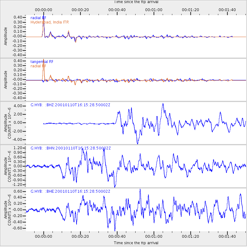
Earthquake location: Kodiak Island Region, Alaska
Earthquake latitude/longitude: 57.1/-153.2
Earthquake time(UTC): 2001/01/10 (010) 16:02:44 GMT
Earthquake Depth: 33 km
Earthquake Magnitude: 6.2 MB, 6.8 MS, 7.1 MW, 6.8 ML
Earthquake Catalog/Contributor: WHDF/NEIC
Network: G GEOSCOPE
Station: HYB Hyderabad, India
Lat/Lon: 17.42 N/78.55 E
Elevation: 510 m
Distance: 94.2 deg
Az: 311.242 deg
Baz: 25.473 deg
Ray Param: 0.04108372
Estimated Moho Depth: 32.5 km
Estimated Crust Vp/Vs: 1.75
Assumed Crust Vp: 6.459 km/s
Estimated Crust Vs: 3.702 km/s
Estimated Crust Poisson's Ratio: 0.26
Radial Match: 97.0125 %
Radial Bump: 303
Transverse Match: 89.95968 %
Transverse Bump: 400
SOD ConfigId: 3744
Insert Time: 2010-02-26 22:40:20.807 +0000
GWidth: 2.5
Max Bumps: 400
Tol: 0.001

Signal To Noise

ChannelStoNSTALTA
G:HYB: :BHN:20010110T16:15:28.50002Z1.25556435.8410254E-84.6521116E-8
G:HYB: :BHE:20010110T16:15:28.50002Z0.97300823.5316766E-83.629647E-8
G:HYB: :BHZ:20010110T16:15:28.50002Z1.09075138.142442E-87.4649854E-8
Arrivals
Ps3.8 SECOND
PpPs14 SECOND
PsPs/PpSs17 SECOND