You are here: Home > Network List > TA - USArray Transportable Network (new EarthScope stations) Stations List
> Station P43A Skaggs, Pawnee, IL, USA > Earthquake Result Viewer
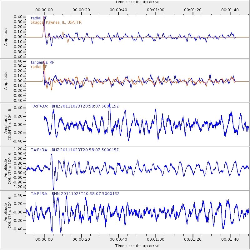
P43A Skaggs, Pawnee, IL, USA - Earthquake Result Viewer
*The percent match for this event was below the threshold and hence no stack was calculated.
| Earthquake location: |
Turkey |
| Earthquake latitude/longitude: |
38.6/43.1 |
| Earthquake time(UTC): |
2011/10/23 (296) 20:45:34 GMT |
| Earthquake Depth: |
5.0 km |
| Earthquake Magnitude: |
6.0 MB, 5.6 MS, 6.0 MW, 5.9 MW |
| Earthquake Catalog/Contributor: |
WHDF/NEIC |
|
| Network: |
TA USArray Transportable Network (new EarthScope stations) |
| Station: |
P43A Skaggs, Pawnee, IL, USA |
| Lat/Lon: |
39.64 N/89.52 W |
| Elevation: |
176 m |
|
| Distance: |
90.8 deg |
| Az: |
325.357 deg |
| Baz: |
35.21 deg |
| Ray Param: |
$rayparam |
*The percent match for this event was below the threshold and hence was not used in the summary stack. |
|
| Radial Match: |
62.460297 % |
| Radial Bump: |
365 |
| Transverse Match: |
43.446774 % |
| Transverse Bump: |
400 |
| SOD ConfigId: |
424168 |
| Insert Time: |
2012-02-16 08:03:57.432 +0000 |
| GWidth: |
2.5 |
| Max Bumps: |
400 |
| Tol: |
0.001 |
|
Signal To Noise
| Channel | StoN | STA | LTA |
| TA:P43A: :BHZ:20111023T20:58:07.500015Z | 2.898221 | 3.7053076E-7 | 1.2784766E-7 |
| TA:P43A: :BHN:20111023T20:58:07.500015Z | 1.8601179 | 1.6527763E-7 | 8.8853305E-8 |
| TA:P43A: :BHE:20111023T20:58:07.500015Z | 1.2295083 | 1.4920222E-7 | 1.2135114E-7 |
| Arrivals |
| Ps | |
| PpPs | |
| PsPs/PpSs | |


