You are here: Home > Network List > TA - USArray Transportable Network (new EarthScope stations) Stations List
> Station F43A Flat Rock, Escanaba, MI, USA > Earthquake Result Viewer
F43A Flat Rock, Escanaba, MI, USA - Earthquake Result Viewer
| Earthquake location: |
Turkey |
| Earthquake latitude/longitude: |
38.6/43.1 |
| Earthquake time(UTC): |
2011/10/23 (296) 20:45:34 GMT |
| Earthquake Depth: |
5.0 km |
| Earthquake Magnitude: |
6.0 MB, 5.6 MS, 6.0 MW, 5.9 MW |
| Earthquake Catalog/Contributor: |
WHDF/NEIC |
|
| Network: |
TA USArray Transportable Network (new EarthScope stations) |
| Station: |
F43A Flat Rock, Escanaba, MI, USA |
| Lat/Lon: |
45.83 N/87.17 W |
| Elevation: |
233 m |
|
| Distance: |
84.8 deg |
| Az: |
327.597 deg |
| Baz: |
36.889 deg |
| Ray Param: |
0.045236934 |
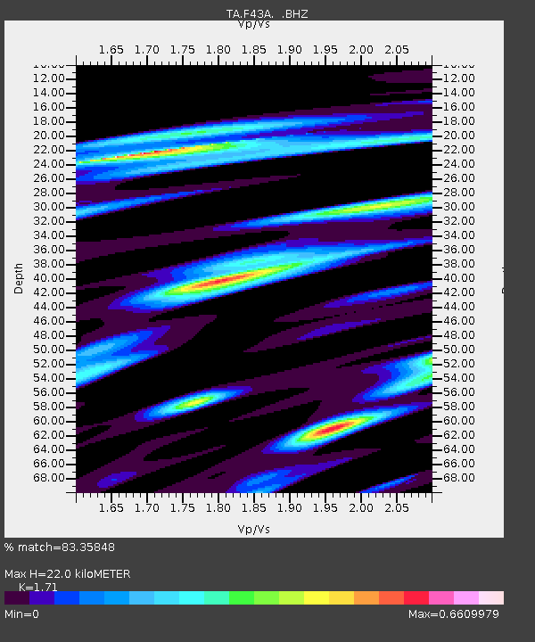
| Estimated Moho Depth: |
22.0 km |
| Estimated Crust Vp/Vs: |
1.71 |
| Assumed Crust Vp: |
6.53 km/s |
| Estimated Crust Vs: |
3.819 km/s |
| Estimated Crust Poisson's Ratio: |
0.24 |
|
| Radial Match: |
83.35848 % |
| Radial Bump: |
303 |
| Transverse Match: |
70.29152 % |
| Transverse Bump: |
392 |
| SOD ConfigId: |
424168 |
| Insert Time: |
2012-02-16 08:06:02.996 +0000 |
| GWidth: |
2.5 |
| Max Bumps: |
400 |
| Tol: |
0.001 |
|
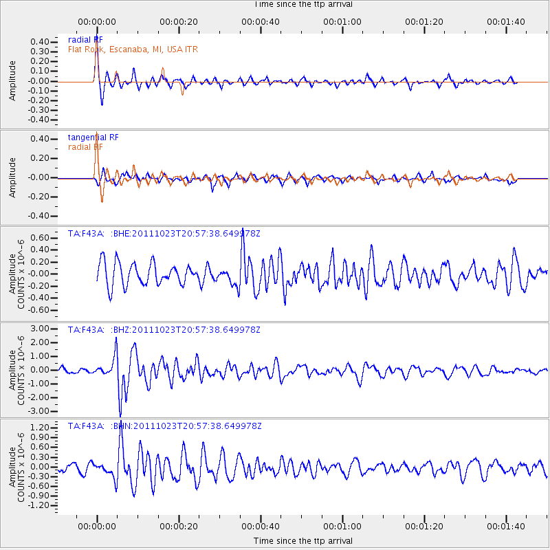
Signal To Noise
| Channel | StoN | STA | LTA |
| TA:F43A: :BHZ:20111023T20:57:38.649978Z | 2.8914912 | 7.275159E-7 | 2.5160577E-7 |
| TA:F43A: :BHN:20111023T20:57:38.649978Z | 2.008868 | 2.3143413E-7 | 1.1520625E-7 |
| TA:F43A: :BHE:20111023T20:57:38.649978Z | 0.8179323 | 1.4634279E-7 | 1.7891797E-7 |
| Arrivals |
| Ps | 2.5 SECOND |
| PpPs | 8.9 SECOND |
| PsPs/PpSs | 11 SECOND |


