You are here: Home > Network List > ZJ12 - Transantarctic Mountains Northern Network Stations List
> Station SAMH East Antarctica > Earthquake Result Viewer
SAMH East Antarctica - Earthquake Result Viewer
| Earthquake location: |
Bouvet Island Region |
| Earthquake latitude/longitude: |
-53.5/8.7 |
| Earthquake time(UTC): |
2014/04/15 (105) 03:57:02 GMT |
| Earthquake Depth: |
12 km |
| Earthquake Magnitude: |
6.9 MWP, 6.8 MI, 6.9 MI |
| Earthquake Catalog/Contributor: |
NEIC PDE/NEIC COMCAT |
|
| Network: |
ZJ Transantarctic Mountains Northern Network |
| Station: |
SAMH East Antarctica |
| Lat/Lon: |
75.20 S/154.00 E |
| Elevation: |
2087 m |
|
| Distance: |
49.5 deg |
| Az: |
168.909 deg |
| Baz: |
206.544 deg |
| Ray Param: |
0.06864206 |
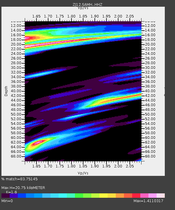
| Estimated Moho Depth: |
20.75 km |
| Estimated Crust Vp/Vs: |
1.60 |
| Assumed Crust Vp: |
6.262 km/s |
| Estimated Crust Vs: |
3.914 km/s |
| Estimated Crust Poisson's Ratio: |
0.18 |
|
| Radial Match: |
83.75145 % |
| Radial Bump: |
321 |
| Transverse Match: |
72.412224 % |
| Transverse Bump: |
400 |
| SOD ConfigId: |
3390531 |
| Insert Time: |
2019-04-11 10:06:07.829 +0000 |
| GWidth: |
2.5 |
| Max Bumps: |
400 |
| Tol: |
0.001 |
|

Signal To Noise
| Channel | StoN | STA | LTA |
| ZJ:SAMH: :HHZ:20140415T04:05:20.97901Z | 38.16777 | 9.421629E-6 | 2.468478E-7 |
| ZJ:SAMH: :HHN:20140415T04:05:20.97901Z | 16.440802 | 4.3482464E-6 | 2.6447898E-7 |
| ZJ:SAMH: :HHE:20140415T04:05:20.97901Z | 5.859176 | 1.5987262E-6 | 2.7285853E-7 |
| Arrivals |
| Ps | 2.1 SECOND |
| PpPs | 8.1 SECOND |
| PsPs/PpSs | 10 SECOND |


