You are here: Home > Network List > TA - USArray Transportable Network (new EarthScope stations) Stations List
> Station G42A Mountain, WI, USA > Earthquake Result Viewer
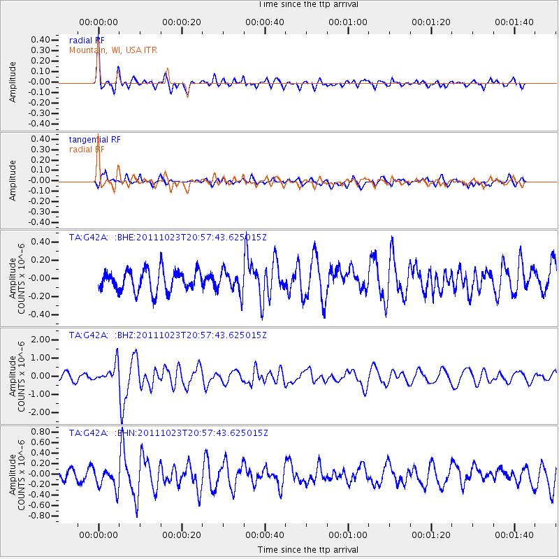
G42A Mountain, WI, USA - Earthquake Result Viewer
| Earthquake location: |
Turkey |
| Earthquake latitude/longitude: |
38.6/43.1 |
| Earthquake time(UTC): |
2011/10/23 (296) 20:45:34 GMT |
| Earthquake Depth: |
5.0 km |
| Earthquake Magnitude: |
6.0 MB, 5.6 MS, 6.0 MW, 5.9 MW |
| Earthquake Catalog/Contributor: |
WHDF/NEIC |
|
| Network: |
TA USArray Transportable Network (new EarthScope stations) |
| Station: |
G42A Mountain, WI, USA |
| Lat/Lon: |
45.24 N/88.43 W |
| Elevation: |
315 m |
|
| Distance: |
85.8 deg |
| Az: |
327.959 deg |
| Baz: |
36.023 deg |
| Ray Param: |
0.044518802 |
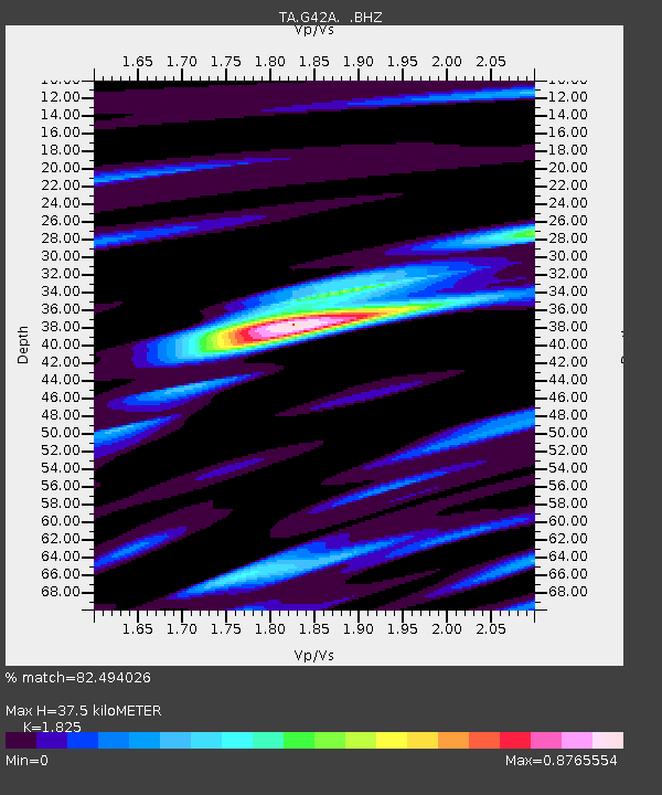
| Estimated Moho Depth: |
37.5 km |
| Estimated Crust Vp/Vs: |
1.83 |
| Assumed Crust Vp: |
6.41 km/s |
| Estimated Crust Vs: |
3.513 km/s |
| Estimated Crust Poisson's Ratio: |
0.29 |
|
| Radial Match: |
82.494026 % |
| Radial Bump: |
400 |
| Transverse Match: |
51.496307 % |
| Transverse Bump: |
400 |
| SOD ConfigId: |
424168 |
| Insert Time: |
2012-02-16 08:06:39.705 +0000 |
| GWidth: |
2.5 |
| Max Bumps: |
400 |
| Tol: |
0.001 |
|
Signal To Noise
| Channel | StoN | STA | LTA |
| TA:G42A: :BHZ:20111023T20:57:43.625015Z | 2.600496 | 5.186434E-7 | 1.9944017E-7 |
| TA:G42A: :BHN:20111023T20:57:43.625015Z | 1.4043047 | 2.0133746E-7 | 1.4337162E-7 |
| TA:G42A: :BHE:20111023T20:57:43.625015Z | 1.0341486 | 1.2039372E-7 | 1.1641821E-7 |
| Arrivals |
| Ps | 4.9 SECOND |
| PpPs | 16 SECOND |
| PsPs/PpSs | 21 SECOND |


