You are here: Home > Network List > CI - Caltech Regional Seismic Network Stations List
> Station MPM Manuel Prospect Mine, California, USA > Earthquake Result Viewer
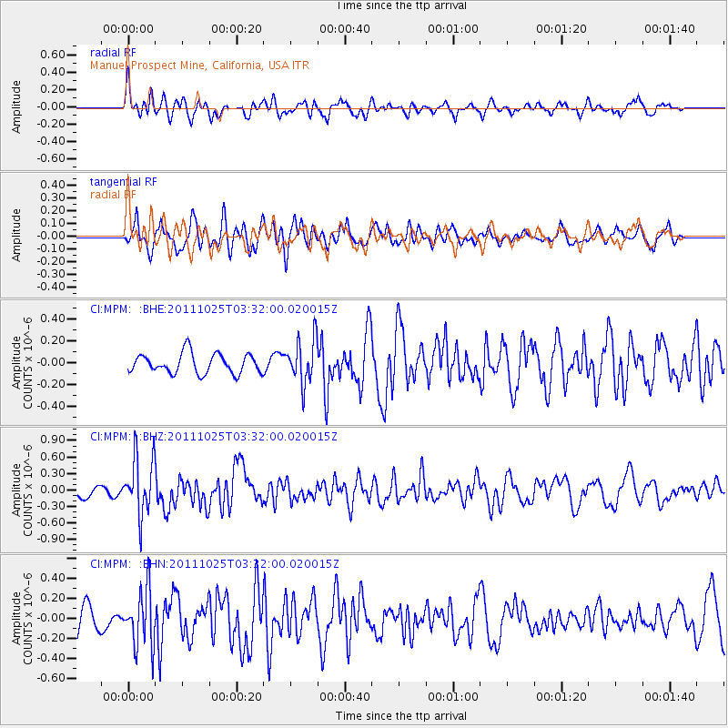
MPM Manuel Prospect Mine, California, USA - Earthquake Result Viewer
*The percent match for this event was below the threshold and hence no stack was calculated.
| Earthquake location: |
Fox Islands, Aleutian Islands |
| Earthquake latitude/longitude: |
52.2/-171.8 |
| Earthquake time(UTC): |
2011/10/25 (298) 03:24:49 GMT |
| Earthquake Depth: |
38 km |
| Earthquake Magnitude: |
5.9 MB, 5.3 MS, 5.7 MW, 5.7 MW |
| Earthquake Catalog/Contributor: |
WHDF/NEIC |
|
| Network: |
CI Caltech Regional Seismic Network |
| Station: |
MPM Manuel Prospect Mine, California, USA |
| Lat/Lon: |
36.06 N/117.49 W |
| Elevation: |
185 m |
|
| Distance: |
41.2 deg |
| Az: |
90.967 deg |
| Baz: |
310.522 deg |
| Ray Param: |
$rayparam |
*The percent match for this event was below the threshold and hence was not used in the summary stack. |
|
| Radial Match: |
62.657833 % |
| Radial Bump: |
400 |
| Transverse Match: |
70.452225 % |
| Transverse Bump: |
400 |
| SOD ConfigId: |
424168 |
| Insert Time: |
2012-02-16 08:23:57.300 +0000 |
| GWidth: |
2.5 |
| Max Bumps: |
400 |
| Tol: |
0.001 |
|
Signal To Noise
| Channel | StoN | STA | LTA |
| CI:MPM: :BHZ:20111025T03:32:00.020015Z | 4.1832747 | 5.2688796E-7 | 1.2595108E-7 |
| CI:MPM: :BHN:20111025T03:32:00.020015Z | 3.031914 | 2.8831715E-7 | 9.509411E-8 |
| CI:MPM: :BHE:20111025T03:32:00.020015Z | 2.2581904 | 2.0291166E-7 | 8.985587E-8 |
| Arrivals |
| Ps | |
| PpPs | |
| PsPs/PpSs | |


