You are here: Home > Network List > CI - Caltech Regional Seismic Network Stations List
> Station SMM Simmler, CA, USA > Earthquake Result Viewer
SMM Simmler, CA, USA - Earthquake Result Viewer
*The percent match for this event was below the threshold and hence no stack was calculated.
| Earthquake location: |
Fox Islands, Aleutian Islands |
| Earthquake latitude/longitude: |
52.2/-171.8 |
| Earthquake time(UTC): |
2011/10/25 (298) 03:24:49 GMT |
| Earthquake Depth: |
38 km |
| Earthquake Magnitude: |
5.9 MB, 5.3 MS, 5.7 MW, 5.7 MW |
| Earthquake Catalog/Contributor: |
WHDF/NEIC |
|
| Network: |
CI Caltech Regional Seismic Network |
| Station: |
SMM Simmler, CA, USA |
| Lat/Lon: |
35.31 N/120.00 W |
| Elevation: |
599 m |
|
| Distance: |
40.1 deg |
| Az: |
93.879 deg |
| Baz: |
311.275 deg |
| Ray Param: |
$rayparam |
*The percent match for this event was below the threshold and hence was not used in the summary stack. |
|
| Radial Match: |
57.529488 % |
| Radial Bump: |
400 |
| Transverse Match: |
72.21766 % |
| Transverse Bump: |
400 |
| SOD ConfigId: |
424168 |
| Insert Time: |
2012-02-16 08:25:00.775 +0000 |
| GWidth: |
2.5 |
| Max Bumps: |
400 |
| Tol: |
0.001 |
|
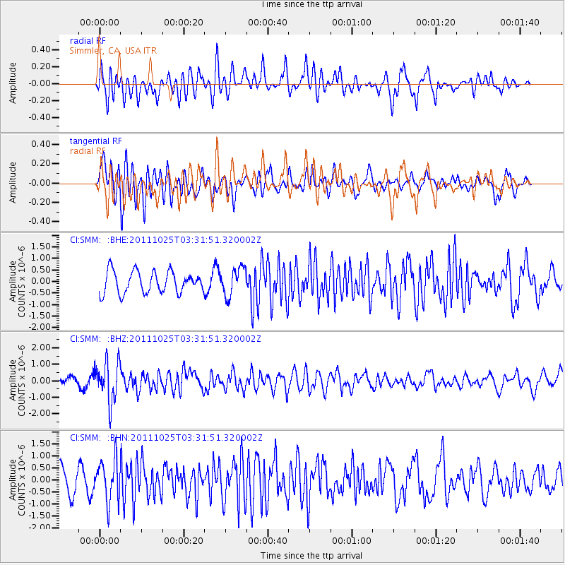
Signal To Noise
| Channel | StoN | STA | LTA |
| CI:SMM: :BHZ:20111025T03:31:51.320002Z | 4.48734 | 1.2220485E-6 | 2.7233247E-7 |
| CI:SMM: :BHN:20111025T03:31:51.320002Z | 1.7271395 | 8.695562E-7 | 5.034661E-7 |
| CI:SMM: :BHE:20111025T03:31:51.320002Z | 1.3106565 | 6.176416E-7 | 4.7124595E-7 |
| Arrivals |
| Ps | |
| PpPs | |
| PsPs/PpSs | |


