You are here: Home > Network List > G - GEOSCOPE Stations List
> Station HYB Hyderabad, India > Earthquake Result Viewer
HYB Hyderabad, India - Earthquake Result Viewer
| Earthquake location: |
Solomon Islands |
| Earthquake latitude/longitude: |
-7.3/156.0 |
| Earthquake time(UTC): |
2001/04/19 (109) 20:58:26 GMT |
| Earthquake Depth: |
20 km |
| Earthquake Magnitude: |
5.7 MB, 6.1 MS, 6.2 MW, 5.9 ME |
| Earthquake Catalog/Contributor: |
WHDF/NEIC |
|
| Network: |
G GEOSCOPE |
| Station: |
HYB Hyderabad, India |
| Lat/Lon: |
17.42 N/78.55 E |
| Elevation: |
510 m |
|
| Distance: |
80.3 deg |
| Az: |
289.031 deg |
| Baz: |
100.814 deg |
| Ray Param: |
0.048365872 |
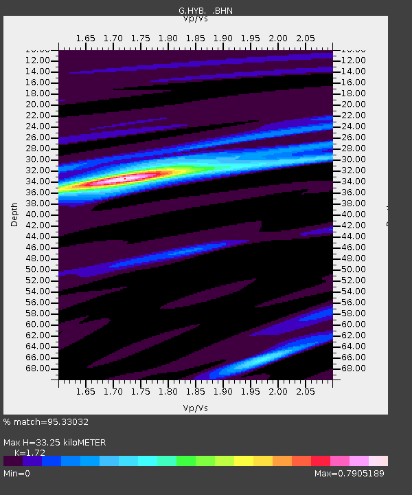
| Estimated Moho Depth: |
33.25 km |
| Estimated Crust Vp/Vs: |
1.72 |
| Assumed Crust Vp: |
6.459 km/s |
| Estimated Crust Vs: |
3.755 km/s |
| Estimated Crust Poisson's Ratio: |
0.24 |
|
| Radial Match: |
95.33032 % |
| Radial Bump: |
269 |
| Transverse Match: |
77.05351 % |
| Transverse Bump: |
400 |
| SOD ConfigId: |
4714 |
| Insert Time: |
2010-02-26 22:40:40.220 +0000 |
| GWidth: |
2.5 |
| Max Bumps: |
400 |
| Tol: |
0.001 |
|

Signal To Noise
| Channel | StoN | STA | LTA |
| G:HYB: :BHN:20010419T21:10:04.15001Z | 0.81192553 | 2.5723606E-8 | 3.1682223E-8 |
| G:HYB: :BHE:20010419T21:10:04.15001Z | 4.476689 | 1.6395329E-7 | 3.6623785E-8 |
| G:HYB: :BHZ:20010419T21:10:04.15001Z | 9.219239 | 4.809788E-7 | 5.2171206E-8 |
| Arrivals |
| Ps | 3.8 SECOND |
| PpPs | 14 SECOND |
| PsPs/PpSs | 17 SECOND |


