You are here: Home > Network List > TA - USArray Transportable Network (new EarthScope stations) Stations List
> Station U57A Blanch, NC, USA > Earthquake Result Viewer
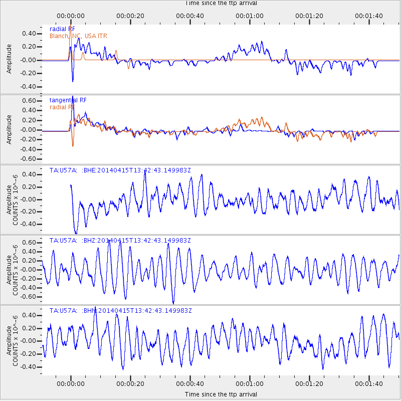
U57A Blanch, NC, USA - Earthquake Result Viewer
*The percent match for this event was below the threshold and hence no stack was calculated.
| Earthquake location: |
Southeast Of Easter Island |
| Earthquake latitude/longitude: |
-36.1/-101.2 |
| Earthquake time(UTC): |
2014/04/15 (105) 13:31:33 GMT |
| Earthquake Depth: |
14 km |
| Earthquake Magnitude: |
5.6 MW |
| Earthquake Catalog/Contributor: |
ISC/ISC |
|
| Network: |
TA USArray Transportable Network (new EarthScope stations) |
| Station: |
U57A Blanch, NC, USA |
| Lat/Lon: |
36.43 N/79.34 W |
| Elevation: |
178 m |
|
| Distance: |
74.9 deg |
| Az: |
18.102 deg |
| Baz: |
198.187 deg |
| Ray Param: |
$rayparam |
*The percent match for this event was below the threshold and hence was not used in the summary stack. |
|
| Radial Match: |
42.745934 % |
| Radial Bump: |
400 |
| Transverse Match: |
68.309746 % |
| Transverse Bump: |
400 |
| SOD ConfigId: |
3390531 |
| Insert Time: |
2019-04-11 10:11:23.696 +0000 |
| GWidth: |
2.5 |
| Max Bumps: |
400 |
| Tol: |
0.001 |
|
Signal To Noise
| Channel | StoN | STA | LTA |
| TA:U57A: :BHZ:20140415T13:42:43.149983Z | 0.8944431 | 1.8823981E-7 | 2.1045477E-7 |
| TA:U57A: :BHN:20140415T13:42:43.149983Z | 1.441742 | 3.2255875E-7 | 2.2372849E-7 |
| TA:U57A: :BHE:20140415T13:42:43.149983Z | 1.0459962 | 1.8369975E-7 | 1.756218E-7 |
| Arrivals |
| Ps | |
| PpPs | |
| PsPs/PpSs | |


