You are here: Home > Network List > US - United States National Seismic Network Stations List
> Station MNTX Cornudas Mountains, Texas, USA > Earthquake Result Viewer
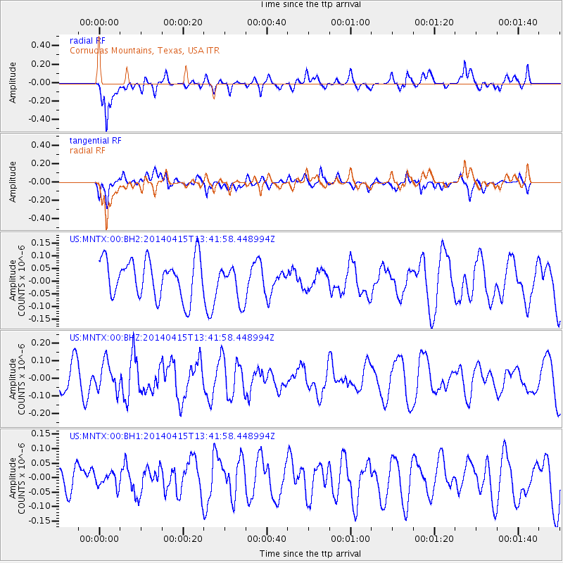
MNTX Cornudas Mountains, Texas, USA - Earthquake Result Viewer
*The percent match for this event was below the threshold and hence no stack was calculated.
| Earthquake location: |
Southeast Of Easter Island |
| Earthquake latitude/longitude: |
-36.1/-101.2 |
| Earthquake time(UTC): |
2014/04/15 (105) 13:31:33 GMT |
| Earthquake Depth: |
14 km |
| Earthquake Magnitude: |
5.6 MW |
| Earthquake Catalog/Contributor: |
ISC/ISC |
|
| Network: |
US United States National Seismic Network |
| Station: |
MNTX Cornudas Mountains, Texas, USA |
| Lat/Lon: |
31.70 N/105.38 W |
| Elevation: |
404 m |
|
| Distance: |
67.5 deg |
| Az: |
356.123 deg |
| Baz: |
176.315 deg |
| Ray Param: |
$rayparam |
*The percent match for this event was below the threshold and hence was not used in the summary stack. |
|
| Radial Match: |
56.45708 % |
| Radial Bump: |
400 |
| Transverse Match: |
51.58612 % |
| Transverse Bump: |
400 |
| SOD ConfigId: |
3390531 |
| Insert Time: |
2019-04-11 10:12:02.863 +0000 |
| GWidth: |
2.5 |
| Max Bumps: |
400 |
| Tol: |
0.001 |
|
Signal To Noise
| Channel | StoN | STA | LTA |
| US:MNTX:00:BHZ:20140415T13:41:58.448994Z | 1.0269581 | 8.174709E-8 | 7.960119E-8 |
| US:MNTX:00:BH1:20140415T13:41:58.448994Z | 0.5310076 | 2.4069607E-8 | 4.532818E-8 |
| US:MNTX:00:BH2:20140415T13:41:58.448994Z | 0.9672477 | 7.327843E-8 | 7.575973E-8 |
| Arrivals |
| Ps | |
| PpPs | |
| PsPs/PpSs | |


