You are here: Home > Network List > CI - Caltech Regional Seismic Network Stations List
> Station LGU LGU, Camarillo, CA, USA > Earthquake Result Viewer
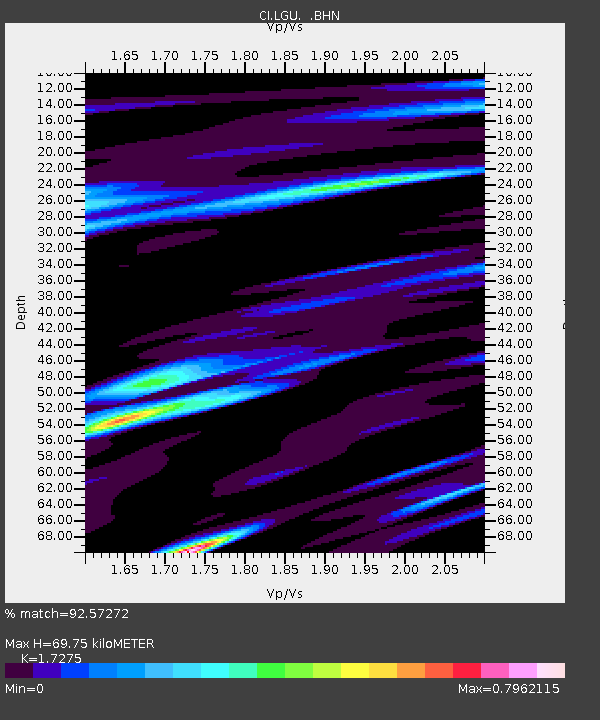
LGU LGU, Camarillo, CA, USA - Earthquake Result Viewer
| Earthquake location: |
Eastern Honshu, Japan |
| Earthquake latitude/longitude: |
39.8/141.5 |
| Earthquake time(UTC): |
2008/07/23 (205) 15:26:19 GMT |
| Earthquake Depth: |
108 km |
| Earthquake Magnitude: |
6.6 MB, 6.8 MW, 6.8 MW |
| Earthquake Catalog/Contributor: |
WHDF/NEIC |
|
| Network: |
CI Caltech Regional Seismic Network |
| Station: |
LGU LGU, Camarillo, CA, USA |
| Lat/Lon: |
34.11 N/119.07 W |
| Elevation: |
416 m |
|
| Distance: |
75.5 deg |
| Az: |
57.717 deg |
| Baz: |
308.285 deg |
| Ray Param: |
0.051382735 |
| Estimated Moho Depth: |
69.75 km |
| Estimated Crust Vp/Vs: |
1.73 |
| Assumed Crust Vp: |
6.1 km/s |
| Estimated Crust Vs: |
3.531 km/s |
| Estimated Crust Poisson's Ratio: |
0.25 |
|
| Radial Match: |
92.57272 % |
| Radial Bump: |
388 |
| Transverse Match: |
87.898506 % |
| Transverse Bump: |
400 |
| SOD ConfigId: |
2504 |
| Insert Time: |
2010-02-25 20:19:32.832 +0000 |
| GWidth: |
2.5 |
| Max Bumps: |
400 |
| Tol: |
0.001 |
|

Signal To Noise
| Channel | StoN | STA | LTA |
| CI:LGU: :BHN:20080723T15:37:21.361011Z | 21.223465 | 7.736827E-6 | 3.645412E-7 |
| CI:LGU: :BHE:20080723T15:37:21.361011Z | 5.175404 | 2.2247648E-6 | 4.298727E-7 |
| CI:LGU: :BHZ:20080723T15:37:21.361011Z | 4.953123 | 1.9929932E-6 | 4.0237106E-7 |
| Arrivals |
| Ps | 8.6 SECOND |
| PpPs | 30 SECOND |
| PsPs/PpSs | 39 SECOND |


